IMAGES TAKEN NEAR TO
Gregory Street, HYDE, SK14 4NJ
Introduction
This page details the photographs taken nearby to Gregory Street, SK14 4NJ by members of the Geograph project.
The Geograph project started in 2005 with the aim of publishing, organising and preserving representative images for every square kilometre of Great Britain, Ireland and the Isle of Man.

There are currently over 7.5m images from over14,400 individuals and you can help contribute to the project by visiting https://www.geograph.org.uk
Image Map
Images are licensed for reuse under creativecommons.org/licenses/by-sa/2.0
Notes
- Clicking on the map will re-center to the selected point.
- The higher the marker number, the further away the image location is from the centre of the postcode.
Image Listing (88 Images Found)
Images are licensed for reuse under creativecommons.org/licenses/by-sa/2.0
Image
Details
Distance
1
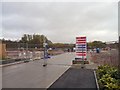
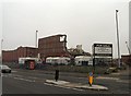
Cotton Mills Development
The Cotton Mills Development on the site of the former Hyde Mill has plans for nearly for almost 300 new houses. About a third have already been built and some are occupied. The rest of the site is still being prepared.
Image: © Gerald England
Taken: 8 Nov 2012
0.03 miles
2
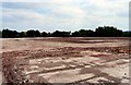
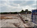
Site of Hyde Mill
The site has been cleared now and the view opened up towards the line of trees between Johnson Brook and Astley High School.
Image: © Gerald England
Taken: 3 Jun 2010
0.05 miles
3
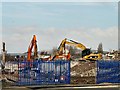
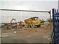
Pike between Two JCBs
As JCBs clear the remains of Hyde Mill Image a new view is afforded of Hartshead Pike Image in Image
Image: © Gerald England
Taken: 22 Feb 2010
0.05 miles
4
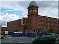
Hyde Mill
Originally the home of "Senior Service". The smell of tobacco permeated the air for about a mile downwind of the factory.
Image: © Gerald England
Taken: 6 Aug 2007
0.05 miles
5

End of an Era
The demolition has just begun of Hyde Mill Image The top of the iconic tower is first thing to go.
Image: © Gerald England
Taken: 15 Sep 2009
0.05 miles
6
Most of Hyde Mill Gone
Hyde Mill Image was completed in 1906. Demolition began in September 2009 Image Compare the view in December 2009 Image
Image: © Gerald England
Taken: 23 Jan 2010
0.06 miles
7
Clearing Hyde Mill
Work is progressing on clearing the site of Hyde Mill following demolition.
Image: © Gerald England
Taken: 19 Mar 2010
0.07 miles
8
New houses on the site of the old Senior Service Factory
Image: © Alexander P Kapp
Taken: 6 Dec 2011
0.07 miles
9
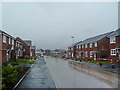
Admirals Way
Admirals Way is the main street of the "Cotton Mills Development" on the site of the former Hyde Mill which was demolished in 2009.
Image: © Gerald England
Taken: 8 Nov 2012
0.07 miles
10
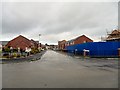
Gregory Street
Originally leading into Hyde Mill, now the mill has been demolished, Gregory Street leads into the car park and offices of Findell Education.
Image: © Gerald England
Taken: 3 Jun 2010
0.07 miles