IMAGES TAKEN NEAR TO
Kestrel Close, HYDE, SK14 4FZ
Introduction
This page details the photographs taken nearby to Kestrel Close, SK14 4FZ by members of the Geograph project.
The Geograph project started in 2005 with the aim of publishing, organising and preserving representative images for every square kilometre of Great Britain, Ireland and the Isle of Man.

There are currently over 7.5m images from over14,400 individuals and you can help contribute to the project by visiting https://www.geograph.org.uk
Image Map
Images are licensed for reuse under creativecommons.org/licenses/by-sa/2.0
Notes
- Clicking on the map will re-center to the selected point.
- The higher the marker number, the further away the image location is from the centre of the postcode.
Image Listing (107 Images Found)
Images are licensed for reuse under creativecommons.org/licenses/by-sa/2.0
Image
Details
Distance
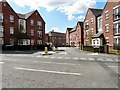
2
Ashton Road
Unclassified road but part of a busy alternative eastern route to Ashton under Lyne bypassing the centre of Hyde from the south.
Ashton House on the right is supported housing consisting of 34 flats, bungalows, built in 1968 and renovated in 1997. It is managed by New Charter Housing Trust Ltd with a main entrance on Victoria Street.
Image: © Gerald England
Taken: 1 May 2013
0.06 miles
3

Garden Street Recreation Ground
Looking from Ashley Street across one of the two football pitches towards Garden Street and Ashton Road.
Image: © Gerald England
Taken: 1 May 2013
0.07 miles
4

Garden Street Recreation Ground
Viewed from Ashton Road looking across the two football pitches. Garden Street is on the left, Ashley Street on the right.
Image: © Gerald England
Taken: 1 May 2013
0.08 miles
5
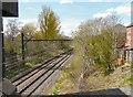
Railway behind Foxwood Drive
Looking from the side of the bridge on Ashton Road at the railway line from Glossop and Newton to Flowery Field and Manchester Piccadilly. On the right are the back gardens of houses in Foxwood Drive.
Image: © Gerald England
Taken: 1 May 2013
0.09 miles
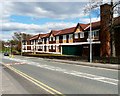
6

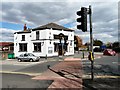
Duke of Sussex
At a busy crossing of minor roads. The left turn is Ashton Road which crosses to become Commercial Brow. The view is from across Clarendon Road which on passing the pub becomes Victoria Street.
Image: © Gerald England
Taken: 19 Feb 2007
0.09 miles
7
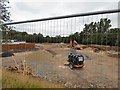
Building work at Clarendon Woods
The forming playing fields at what was Hyde Grammar School and more recently Clarendon Sixth Form College are being prepared for the building of an estate of new houses to be called Clarendon Woods.
Image: © Gerald England
Taken: 24 Jul 2018
0.10 miles
8
Duke of Sussex
On the corner of Ashton Road and Victoria Street.
Image: © Gerald England
Taken: 1 May 2013
0.10 miles
9
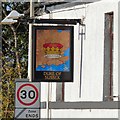
Sign for the Duke of Sussex
The sign for the Duke of Sussex Image
Image: © Gerald England
Taken: 19 Oct 2015
0.10 miles
10
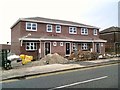
New houses on Victoria Street
Under construction.
Image: © Gerald England
Taken: 15 Feb 2017
0.11 miles