IMAGES TAKEN NEAR TO
Sidley Place, HYDE, SK14 2QA
Introduction
This page details the photographs taken nearby to Sidley Place, SK14 2QA by members of the Geograph project.
The Geograph project started in 2005 with the aim of publishing, organising and preserving representative images for every square kilometre of Great Britain, Ireland and the Isle of Man.

There are currently over 7.5m images from over14,400 individuals and you can help contribute to the project by visiting https://www.geograph.org.uk
Image Map
Images are licensed for reuse under creativecommons.org/licenses/by-sa/2.0
Notes
- Clicking on the map will re-center to the selected point.
- The higher the marker number, the further away the image location is from the centre of the postcode.
Image Listing (158 Images Found)
Images are licensed for reuse under creativecommons.org/licenses/by-sa/2.0
Image
Details
Distance
1
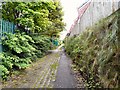
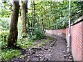
Path to Godley
Steep path to Godley from Godley Brook. On the right are houses in Woodland View. On the left behind the fence is Godley Primary School.
Image: © Gerald England
Taken: 31 May 2011
0.07 miles
2
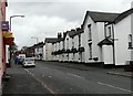
High Street Godley
St John's Terrace on the right dates from 1860 but has obviously been much modernised in recent years.
Image: © Gerald England
Taken: 20 Nov 2008
0.07 miles
3
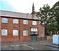
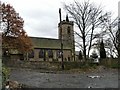
Parish Centre
The Parish Centre at Godley next to St John the Baptist's Church. Originally it was an infant school and an inscribed stone dates it to 1849 Image
Image: © Gerald England
Taken: 31 May 2011
0.07 miles
4
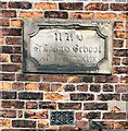
St John's School 1849
Date stone on St John's School, Godley, now Parish Centre Image
Image: © Gerald England
Taken: 31 May 2011
0.07 miles
5
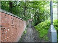
Steep path by Godley Wood
Steep path from Godley towards Godley Brook. On the left is Godley Wood. On the right behind the wall is Godley Primary School.
Image: © Gerald England
Taken: 31 May 2011
0.08 miles
6
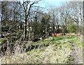
Footpath up to Godley
Steep footpath towards Godley from the valley of the Godley Brook.
Image: © Gerald England
Taken: 31 May 2011
0.09 miles
7
Godley Footpath
Footpath alongside Godley Brook. To the right a steep path leads up to Godley village.
Image: © Gerald England
Taken: 26 Mar 2012
0.09 miles
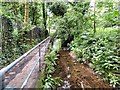
8
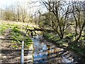
Godley Brook
Looking upstream from near its confluence with Werneth Brook.
Image: © Gerald England
Taken: 26 Mar 2012
0.10 miles
9
Godley St John's
The rear of St John the Baptist's Church, Godley from the portion of Sheffield Road now cul-de-sacced to the right by the M67 motorway.
Image: © Gerald England
Taken: 20 Nov 2008
0.10 miles
10
Godley Brook
From near its confluence with Werneth Brook.
Image: © Gerald England
Taken: 3 Aug 2015
0.10 miles