IMAGES TAKEN NEAR TO
Commercial Street, HYDE, SK14 2JD
Introduction
This page details the photographs taken nearby to Commercial Street, SK14 2JD by members of the Geograph project.
The Geograph project started in 2005 with the aim of publishing, organising and preserving representative images for every square kilometre of Great Britain, Ireland and the Isle of Man.

There are currently over 7.5m images from over14,400 individuals and you can help contribute to the project by visiting https://www.geograph.org.uk
Image Map
Images are licensed for reuse under creativecommons.org/licenses/by-sa/2.0
Notes
- Clicking on the map will re-center to the selected point.
- The higher the marker number, the further away the image location is from the centre of the postcode.
Image Listing (202 Images Found)
Images are licensed for reuse under creativecommons.org/licenses/by-sa/2.0
Image
Details
Distance
1
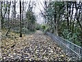
Footpath from Godley
A footpath between Godley and Hyde. On the right lies the valley of Godley Brook and Commercial Street. On the left lies the M67 motorway.
Image: © Gerald England
Taken: 20 Nov 2008
0.04 miles
2
Footpath to Godley
A footpath between Hyde and Godley. On the left lies the valley of Godley Brook and Commercial Street. On the right lies the M67 motorway. Ahead is Halton Street.
Image: © Gerald England
Taken: 20 Nov 2008
0.06 miles
3
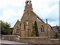
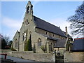
St Paul's, Newton
St Paul's Roman Catholic Church at Newton.
Image: © Gerald England
Taken: 5 Jun 2009
0.07 miles
4
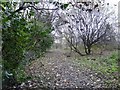
Godley Brook
Near to Godfrey Mill Image On the left is Commercial Street and on the right is a footpath through woods. This is just a little way upstream from Image One arm of Godley Brook comes down off Matley Moor, whilst another arm comes through Godley Vale Image and is culverted under the M67 motorway to join the other arm here.
Image: © Gerald England
Taken: 20 Nov 2008
0.07 miles
5

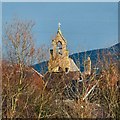
St Paul's Bell Tower
A view of the bell tower of St Paul's RC Church, Newton taken with a zoom lens from the footbridge over the M67.
Image: © Gerald England
Taken: 11 Jan 2008
0.08 miles
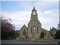
6
The top of St Paul's
The top of St Paul's RC church viewed with a zoom from near the end of Hamnett Street.
St Paul's Roman Catholic Church was founded on Hamnett Street in 1848, meeting in rooms above a factory. In 1852, Mr Ashton, owner of the Newton Banks Print Works, gave a plot of land off Newton St in Newton Moor, to build a Catholic church. The foundation stone was laid on Friday, 20th May 1853 and the church opened for worship on 21st June 1854.
This information is from a 120pp book by Bernard Marshall written in 1998 to celebrate the 150th anniversary of the parish. It is downloadable as a pdf file and contains a wealth of information. http://www.marshallfamily.net/fam/dadsbook.pdf
Image: © Gerald England
Taken: 17 Jan 2015
0.08 miles
8
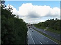
M67 at Hyde
The M67 motorway towards Hyde and Manchester viewed from the Halton Street bridge.
Image: © Gerald England
Taken: 31 May 2011
0.08 miles
10
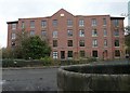
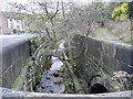
Godfrey Mill
At the bottom of Commercial Street, this old mill was converted into apartments in 2006.
Image: © Gerald England
Taken: 20 Nov 2008
0.10 miles