IMAGES TAKEN NEAR TO
Nelson Street, HYDE, SK14 1PB
Introduction
This page details the photographs taken nearby to Nelson Street, SK14 1PB by members of the Geograph project.
The Geograph project started in 2005 with the aim of publishing, organising and preserving representative images for every square kilometre of Great Britain, Ireland and the Isle of Man.

There are currently over 7.5m images from over14,400 individuals and you can help contribute to the project by visiting https://www.geograph.org.uk
Image Map
Images are licensed for reuse under creativecommons.org/licenses/by-sa/2.0
Notes
- Clicking on the map will re-center to the selected point.
- The higher the marker number, the further away the image location is from the centre of the postcode.
Image Listing (1330 Images Found)
Images are licensed for reuse under creativecommons.org/licenses/by-sa/2.0
Image
Details
Distance
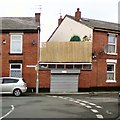
1
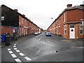
Nelson Street, Hyde
Viewed from the corner with Travis Street.
Image: © John Topping
Taken: 30 Oct 2013
0.01 miles
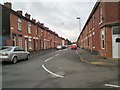
2
Junction of Nelson Street and Travis Street
Some online maps mark the street to the right as a continuation of Travis Street but street name plates confirm that is Nelson Street which bends to the right.
Image: © Gerald England
Taken: 13 Sep 2013
0.01 miles
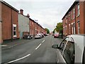
3
Junction of Travis Street and Nelson Street
Looking down Nelson Street coming from Market Street. Travis Street goes off to the left. Nelson Street continues to the right then takes a sharp left to join Ridling Lane. That dog-leg section carrying one-way traffic between Ridling Lane and Travis Street is marked on some street maps and Google Maps as a continuation of "Travis Street" despite the clear street name signs Image
Image: © Gerald England
Taken: 28 Dec 2010
0.01 miles
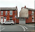
4
Street Signs (Travis Street/Nelson Street)
Street name signs at the junction of Travis Street and Nelson Street Image
Image: © Gerald England
Taken: 28 Dec 2010
0.01 miles
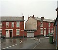
5
Corner of Travis Street and Nelson Street
Looking down Nelson Street coming from Market Street. Travis Street goes off to the left. Nelson Street continues to the right then takes a sharp left to join Ridling Lane. That dog-leg section carrying one-way traffic between Ridling Lane and Travis Street is marked on some street maps and Google Maps as a continuation of "Travis Street" despite the clear street name signs Image
Image: © Gerald England
Taken: 4 Apr 2016
0.01 miles
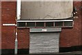
6
Nelson Street
Running from Travis Street to Market Street.
Image: © Gerald England
Taken: 21 Jul 2010
0.03 miles
7
Travis Street
Leading from Nelson Street to Union Street.
Image: © Gerald England
Taken: 21 Jul 2010
0.03 miles
8
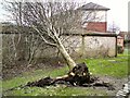
Uprooted tree
An uprooted tree at the rear of Travis Street.
See also Image
Image: © Gerald England
Taken: 13 Feb 2014
0.03 miles
9
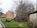
Blown down in the gales
At the rear of Travis Street. The tree doesn't appear to have damaged the garages on top of which it has fallen.
See also Image
Image: © Gerald England
Taken: 13 Feb 2014
0.03 miles
10
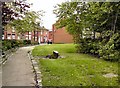
Tree Stump
The stump of a tree, at the rear of Travis Street, that had blown down in the February gales Image
Image: © Gerald England
Taken: 2 May 2014
0.03 miles