IMAGES TAKEN NEAR TO
Daisy Street, STOCKPORT, SK1 3RA
Introduction
This page details the photographs taken nearby to Daisy Street, SK1 3RA by members of the Geograph project.
The Geograph project started in 2005 with the aim of publishing, organising and preserving representative images for every square kilometre of Great Britain, Ireland and the Isle of Man.

There are currently over 7.5m images from over14,400 individuals and you can help contribute to the project by visiting https://www.geograph.org.uk
Image Map
Images are licensed for reuse under creativecommons.org/licenses/by-sa/2.0
Notes
- Clicking on the map will re-center to the selected point.
- The higher the marker number, the further away the image location is from the centre of the postcode.
Image Listing (122 Images Found)
Images are licensed for reuse under creativecommons.org/licenses/by-sa/2.0
Image
Details
Distance
1
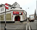
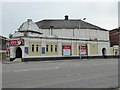
Wellington Picture House
Riley's Snooker Club on Wellington Road South was formerly the Wellington Picture House.
Image: © Gerald England
Taken: 29 Apr 2010
0.02 miles
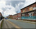
2
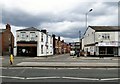
Daisy Street
Off Wellington Road South.
To the left is Jasmine House On the right is SK Pizza.
Image: © Gerald England
Taken: 10 Jun 2019
0.03 miles
3
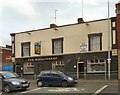
The Wheatsheaf
At the end of Higher Hillgate.
Image
Image: © Gerald England
Taken: 29 Apr 2010
0.04 miles
4
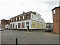
Former cinema
Seen from Higher Hillgate. It is apparently disused and was latterly a Rileys snooker hall.
Image: © Kevin Waterhouse
Taken: 11 Jun 2024
0.05 miles
5
Former Wellington picture House, Stockport
Now a pool centre.
Image: © Chris Allen
Taken: 1 May 2016
0.05 miles
6
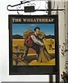
Sign of The Wheatsheaf
The sign for The Wheatsheaf on Higher Hillgate Image
Image: © Gerald England
Taken: 29 Apr 2010
0.06 miles
7
Wellington Grove
Off Wellington Road South.
Image: © Gerald England
Taken: 10 Jun 2019
0.06 miles
8
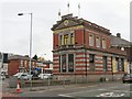
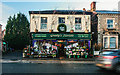
Stockport Carpet Centre
Half a mile from Stockport Town Hall Image at the corner of Higher Hillgate a pre-Worboys signpost Image stands outside the Stockport Carpet Centre. The building was formerly a branch of the Manchester and County Bank.
Image: © Gerald England
Taken: 29 Apr 2010
0.06 miles
9
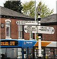
Bramhall 3
A pre-Worboys roadsign on the A6 at the junction of Higher Hillgate Image, Wellington Road South, Bramhall Lane and Buxton Road. It is half a mile from a similar sign Image
Image: © Gerald England
Taken: 29 Apr 2010
0.06 miles
10
Gresty's Florists
Gresty's Florists on Buxton Road.
Image: © Peter McDermott
Taken: 2 Jan 2014
0.07 miles