IMAGES TAKEN NEAR TO
Chadwick Street, STOCKPORT, SK1 3QQ
Introduction
This page details the photographs taken nearby to Chadwick Street, SK1 3QQ by members of the Geograph project.
The Geograph project started in 2005 with the aim of publishing, organising and preserving representative images for every square kilometre of Great Britain, Ireland and the Isle of Man.

There are currently over 7.5m images from over14,400 individuals and you can help contribute to the project by visiting https://www.geograph.org.uk
Image Map
Images are licensed for reuse under creativecommons.org/licenses/by-sa/2.0
Notes
- Clicking on the map will re-center to the selected point.
- The higher the marker number, the further away the image location is from the centre of the postcode.
Image Listing (277 Images Found)
Images are licensed for reuse under creativecommons.org/licenses/by-sa/2.0
Image
Details
Distance
1
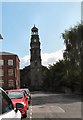
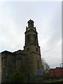
St Thomas's Church West End
The view from St Thomas Place.
Image: © Gerald England
Taken: 22 Aug 2014
0.02 miles
2

South west corner of St Thomas' church, Stockport
There is an Ordnance Survey 1st Geodetic levelling bench mark and bolt on the left hand face of the church wall - Image
Image: © John S Turner
Taken: 5 Apr 2018
0.03 miles
3
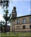
The South side of St Thomas's
The gravestones have been mostly flattened for the ease of maintenance and the large tree has had its branches cut back.
Image: © Gerald England
Taken: 22 Aug 2015
0.03 miles
4

St Thomas's clock face
The southern-facing face.
Image: © Gerald England
Taken: 22 Aug 2015
0.03 miles
5
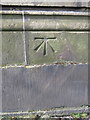
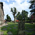
1GL bolt bench mark on St Thomas' church, Stockport
This Ordnance Survey 1st Geodetic Levelling bench mark and bolt is near the south west corner of St Thomas's church. See also Image
Image: © John S Turner
Taken: 5 Apr 2018
0.03 miles
6
St Thomas's Church
The West end from St Thomas's Place.
Image: © Gerald England
Taken: 22 Aug 2015
0.03 miles
7
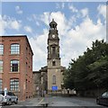
St Thomas's Church
St Thomas' Parish Church was opened in 1825. It is in the process of restoration.
Image: © Gerald England
Taken: 9 Dec 2010
0.03 miles
8
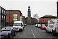
St Thomas's Place, Stockport
The road is dominated by St Thomas's Church, a Grade I listed Anglican church. However the current state of the road does not set it off to best advantage.
Image: © Bill Boaden
Taken: 12 Mar 2015
0.03 miles
9
St Thomas's churchyard
The burial ground on the south side of the church. Most of the gravestones have been flattened for ease of maintenance and the tree in the middle has been pollarded.
Image: © Gerald England
Taken: 22 Aug 2015
0.04 miles
10

Inside St Thomas's Church
Looking from east to west. The pews in the gallery are original Georgian ones whilst the others are Victorian replacements.
Image: © Gerald England
Taken: 22 Aug 2014
0.04 miles