IMAGES TAKEN NEAR TO
Holt Street, STOCKPORT, SK1 3PY

Introduction

This page details the photographs taken nearby to Holt Street, SK1 3PY by members of the Geograph project.

The Geograph project started in 2005 with the aim of publishing, organising and preserving representative images for every square kilometre of Great Britain, Ireland and the Isle of Man.

There are currently over 7.5m images from over14,400 individuals and you can help contribute to the project by visiting https://www.geograph.org.uk

Image Map


Images are licensed for reuse under creativecommons.org/licenses/by-sa/2.0
Notes
  • Clicking on the map will re-center to the selected point.
  • The higher the marker number, the further away the image location is from the centre of the postcode.

Image Listing (186 Images Found)

Images are licensed for reuse under creativecommons.org/licenses/by-sa/2.0
  • ...
Image
Details
Distance
1
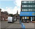
Holt Street
The short street off Higher Hillgate leads to St Thomas's Parish Church. On the right is Burley House which has been converted into apartments. The ground floor is home to hire company HSS.
Image: © Gerald England Taken: 22 Aug 2014
0.01 miles
2
Hillgate Pharmacy
Located at 50 Higher Hillgate on the corner of Holt Street in a building erected in 1869 Image It has the look of an old Co-op building but in fact the Co-op pharmacy is two doors away at #54 with a sandwich shop between them.
Image: © Gerald England Taken: 22 Aug 2014
0.02 miles
3
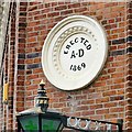
Erected AD 1869
Date plaque on Hillgate Pharmacy Image The plaque looks a little out of place against the red brickwork. The arms supporting the lamp beneath have horseshoes attached. Does a pharmacy need luck?
Image: © Gerald England Taken: 22 Aug 2014
0.02 miles
4
Hazardous Headstones
Warning notice at the entrance to the graveyard at St Thomas's.
Image: © Gerald England Taken: 22 Aug 2014
0.02 miles
5
Pivot bench mark in Marriott Street, Stockport
This Ordnance Survey pivot bench mark is on the top of the north east corner of the perimeter wall of St Thomas' churchyard. See also Image
Image: © John S Turner Taken: 5 Apr 2018
0.03 miles
6
Apartment block in Marriott Street, Stockport
Looking east along Marriott Street towards a modern apartment block. The railings and low wall in the foreground mark the north east corner of St Thomas' churchyard, and there is an Ordnance Survey pivot bench mark on top of the wall - Image
Image: © John S Turner Taken: 5 Apr 2018
0.03 miles
7
Caf? at corner of Mowbray Street
This corner is where Middle Hillgate changes to Higher Hillgate.
Image: © Gerald England Taken: 22 Aug 2014
0.05 miles
8
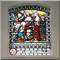
St Thomas's Stained Glass (4)
One of the stained glass windows in St Thomas's Church.
Image: © Gerald England Taken: 22 Aug 2014
0.05 miles
9
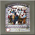
St Thomas's Stained Glass (5)
One of the stained glass windows in St Thomas's Church.
Image: © Gerald England Taken: 22 Aug 2014
0.05 miles
10
St Thomas's Organ
The three-manual organ was made in 1834 by Samuel Renn. Its choir division was added in 1890 by Alex Young, and the organ was cleaned and overhauled in 1961 by Jardine. http://www.npor.org.uk/NPORView.html?RI=N01993
Image: © Gerald England Taken: 22 Aug 2014
0.05 miles
  • ...