IMAGES TAKEN NEAR TO
Higher Hillgate, STOCKPORT, SK1 3HD
Introduction
This page details the photographs taken nearby to Higher Hillgate, SK1 3HD by members of the Geograph project.
The Geograph project started in 2005 with the aim of publishing, organising and preserving representative images for every square kilometre of Great Britain, Ireland and the Isle of Man.

There are currently over 7.5m images from over14,400 individuals and you can help contribute to the project by visiting https://www.geograph.org.uk
Image Map
Images are licensed for reuse under creativecommons.org/licenses/by-sa/2.0
Notes
- Clicking on the map will re-center to the selected point.
- The higher the marker number, the further away the image location is from the centre of the postcode.
Image Listing (94 Images Found)
Images are licensed for reuse under creativecommons.org/licenses/by-sa/2.0
Image
Details
Distance
1
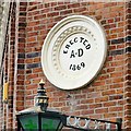
Erected AD 1869
Date plaque on Hillgate Pharmacy Image The plaque looks a little out of place against the red brickwork. The arms supporting the lamp beneath have horseshoes attached. Does a pharmacy need luck?
Image: © Gerald England
Taken: 22 Aug 2014
0.06 miles
2
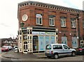
Hillgate Pharmacy
Located at 50 Higher Hillgate on the corner of Holt Street in a building erected in 1869 Image It has the look of an old Co-op building but in fact the Co-op pharmacy is two doors away at #54 with a sandwich shop between them.
Image: © Gerald England
Taken: 22 Aug 2014
0.06 miles
3
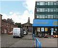
Holt Street
The short street off Higher Hillgate leads to St Thomas's Parish Church. On the right is Burley House which has been converted into apartments. The ground floor is home to hire company HSS.
Image: © Gerald England
Taken: 22 Aug 2014
0.06 miles
4
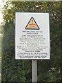
Hazardous Headstones
Warning notice at the entrance to the graveyard at St Thomas's.
Image: © Gerald England
Taken: 22 Aug 2014
0.07 miles
5
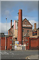
Royal Oak Brewery, Stockport
The former Royal Oak Brewery is currently being demolished. In latter years it was part of the Whitbread empire.
Image: © Alan Murray-Rust
Taken: 16 Sep 2007
0.07 miles
6
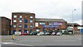
Swallow Mill Business Centre
On Hempshaw Lane
Image: © Kevin Waterhouse
Taken: 11 Jun 2024
0.08 miles
7
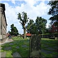
St Thomas's churchyard
The burial ground on the south side of the church. Most of the gravestones have been flattened for ease of maintenance and the tree in the middle has been pollarded.
Image: © Gerald England
Taken: 22 Aug 2015
0.08 miles
8
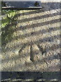
Pivot bench mark in Marriott Street, Stockport
This Ordnance Survey pivot bench mark is on the top of the north east corner of the perimeter wall of St Thomas' churchyard. See also Image
Image: © John S Turner
Taken: 5 Apr 2018
0.08 miles
9
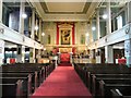
Inside St Thomas's
Looking west to east. The original Georgian pews have been replaced by Victorian pews. Above the High Altar is a painting of the "Transfiguration of Our Lord", a copy of part of a painting by Raphael which hangs in the Vatican. The East wall is decorated with acanthus leaf, a popular classical Greek design.
Image: © Gerald England
Taken: 22 Aug 2014
0.08 miles
10
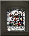
St Thomas's Stained Glass (1)
One of the stained glass windows in St Thomas's Church.
Image: © Gerald England
Taken: 22 Aug 2014
0.08 miles