IMAGES TAKEN NEAR TO
Bullock Street, SK1 3GN
Introduction
This page details the photographs taken nearby to Bullock Street, SK1 3GN by members of the Geograph project.
The Geograph project started in 2005 with the aim of publishing, organising and preserving representative images for every square kilometre of Great Britain, Ireland and the Isle of Man.

There are currently over 7.5m images from over14,400 individuals and you can help contribute to the project by visiting https://www.geograph.org.uk
Image Map
Images are licensed for reuse under creativecommons.org/licenses/by-sa/2.0
Notes
- Clicking on the map will re-center to the selected point.
- The higher the marker number, the further away the image location is from the centre of the postcode.
Image Listing (110 Images Found)
Images are licensed for reuse under creativecommons.org/licenses/by-sa/2.0
Image
Details
Distance
1
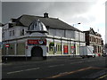
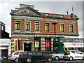
Former Wellington Picture House
Now a snooker and pool hall; on Wellington Road South, opposite Bramhall Lane.
Image: © Peter Barr
Taken: 15 Feb 2013
0.02 miles
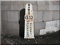
2
Old Direction Sign - Signpost by the A6, Buxton Road,
Annulus finial - 4 arms; Cheshire CC post by the A6, in parish of Stockport (Stockport District), on the northeast side of the junction of the A6 Wellington Road South and Higher Hillgate.
To be surveyed
Milestone Society National ID: CH_SJ8989B
Image: © Milestone Society
Taken: 1 Jan 2006
0.02 miles
3
Old Boundary Marker by the A6, Wellington Road South, Stockport
Parish Boundary Marker by the A6, in parish of Stockport (Stockport District), Wellington Road South/Higher Hillgate junction, against wall of bank.
Surveyed
Milestone Society National ID: CH_STOBAR01pb.
Image: © Milestone Society
Taken: Unknown
0.03 miles
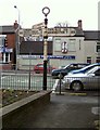
4
Cale Green
View along the A6 at Cale Green, Stockport. The right turn ahead down Higher Hillgate is a route through to the M60.
Image: © Andy Farrington
Taken: 20 Jun 2011
0.03 miles
5
The former Manchester and County Bank Ltd
Now the Stockport Carpet Centre, on Wellington Road South (A6).
Image: © Peter Barr
Taken: 15 Feb 2013
0.03 miles
6
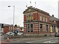
Stockport Carpet Centre
Half a mile from Stockport Town Hall Image at the corner of Higher Hillgate a pre-Worboys signpost Image stands outside the Stockport Carpet Centre. The building was formerly a branch of the Manchester and County Bank.
Image: © Gerald England
Taken: 29 Apr 2010
0.03 miles
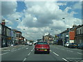
7
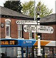
Bramhall 3
A pre-Worboys roadsign on the A6 at the junction of Higher Hillgate Image, Wellington Road South, Bramhall Lane and Buxton Road. It is half a mile from a similar sign Image
Image: © Gerald England
Taken: 29 Apr 2010
0.03 miles
8
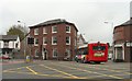
The Blossoms
At the corner of Buxton Road and Bramhall Lane.
Image: © Gerald England
Taken: 29 Apr 2010
0.04 miles
9
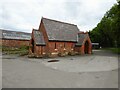
North Chapel
A former Roman Catholic mortuary chapel in Stockport Borough Cemetery
Image: © Kevin Waterhouse
Taken: 11 Jun 2024
0.04 miles
10
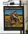
Sign of The Wheatsheaf
The sign for The Wheatsheaf on Higher Hillgate Image
Image: © Gerald England
Taken: 29 Apr 2010
0.04 miles