IMAGES TAKEN NEAR TO
Canal Street, STOCKPORT, SK1 3BZ

Introduction

This page details the photographs taken nearby to Canal Street, SK1 3BZ by members of the Geograph project.

The Geograph project started in 2005 with the aim of publishing, organising and preserving representative images for every square kilometre of Great Britain, Ireland and the Isle of Man.

There are currently over 7.5m images from over14,400 individuals and you can help contribute to the project by visiting https://www.geograph.org.uk

Image Map


Images are licensed for reuse under creativecommons.org/licenses/by-sa/2.0
Notes
  • Clicking on the map will re-center to the selected point.
  • The higher the marker number, the further away the image location is from the centre of the postcode.

Image Listing (143 Images Found)

Images are licensed for reuse under creativecommons.org/licenses/by-sa/2.0
  • ...
Image
Details
Distance
1
Canal Street
From the corner of Alberta Street.
Image: © Gerald England Taken: 22 Aug 2015
0.03 miles
2
Alberta Street
Leading from Middle Hillgate to Canal Street although vehicular access at the bottom is blocked off.
Image: © Gerald England Taken: 22 Aug 2015
0.04 miles
3
10 Canal Street
Vacant offices on the corner of Welcroft Street.
Image: © Gerald England Taken: 22 Aug 2015
0.07 miles
4
Memorial to the Stockport air crash. June 1967.
A British Midland Airways Argonaut on a flight from Majorca, crashed at Hopes Carr in the middle of Stockport on 4th June 1967. 72 people on the aircraft died.
Image: © Jeff Tomlinson Taken: 8 Oct 2006
0.08 miles
5
Former Golden Lion pub in Shaw Heath
Now Cartwright and Gross Architects on Higher hillgate between Higher Barlow Row and Alberta Street.
Image: © Bobby Clegg Taken: 4 Aug 2014
0.10 miles
6
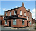
The Waterloo
On the corner of Waterloo Road and Canal Street. Image
Image: © Gerald England Taken: 9 Dec 2010
0.10 miles
7
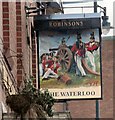
Sign of The Waterloo
The sign for the Waterloo Image
Image: © Gerald England Taken: 9 Dec 2010
0.10 miles
8
Bench mark on the former pub 'The Golden Lion', 89 Middle Hillgate, Stockport
This Ordnance Survey bench mark is on the north west corner of the former public house 'The Golden Lion', 89 Middle Hillgate, Stockport. The cut mark dates to the first O.S. survey before 1851. The building is now the offices of Cartwright and Gross, Architects, and the road on the left is now Alberta Street, but formerly Angel Street. See also Image
Image: © John S Turner Taken: 5 Apr 2018
0.10 miles
9
Cartwright and Gross Architects, formerly 'The Golden Lion' public house
Looking across Middle Hillgate, Stockport towards the former pub 'The Golden Lion'. The building is now the offices of Cartwright and Gross, Architects, and there is an early Ordnance Survey bench mark on the left hand corner of the building - Image The road on the left is Alberta Street but used to be called Angel Street until the middle of the 20th century.
Image: © John S Turner Taken: 5 Apr 2018
0.10 miles
10
The former Waterloo
Another Robinsons pub Image that has bitten the dust.
Image: © Gerald England Taken: 5 Jan 2018
0.11 miles
  • ...