IMAGES TAKEN NEAR TO
Collier Street, GLOSSOP, SK13 8LS
Introduction
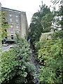
This page details the photographs taken nearby to Collier Street, SK13 8LS by members of the Geograph project.
The Geograph project started in 2005 with the aim of publishing, organising and preserving representative images for every square kilometre of Great Britain, Ireland and the Isle of Man.

There are currently over 7.5m images from over14,400 individuals and you can help contribute to the project by visiting https://www.geograph.org.uk
Image Map (Loading...)


Getting Data...Please wait
Leaflet Map data © OpenStreetMap
Images are licensed for reuse under creativecommons.org/licenses/by-sa/2.0
Notes
- Clicking on the map will re-center to the selected point.
- The higher the marker number, the further away the image location is from the centre of the postcode.
Image Listing (217 Images Found)
Images are licensed for reuse under creativecommons.org/licenses/by-sa/2.0
Image
Details
Distance
1
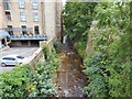
Glossop Brook
Glossop Brook as viewed from Victoria Bridge
Image: © Paul Foster
Taken: 28 Sep 2023
0.03 miles
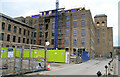
2
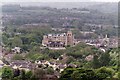
Glossop
Buildings in Glossop Town Centre.
Image: © Peter McDermott
Taken: 25 May 2015
0.03 miles
3
Glossop Brook
Looking upstream from Victoria Bridge. The former mill on the left is part of the Howard Town development which includes a Travelodge, an Edinburgh Woollen Mill shop and a Wetherspoons pub "The Smithy Fold".
Image: © Gerald England
Taken: 5 Aug 2017
0.03 miles
4
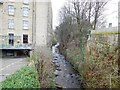
Glossop Brook
Upstream from Victoria Street.
Image: © Gerald England
Taken: 15 Feb 2023
0.03 miles
5
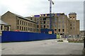
Howardtown Mills, Glossop
This was a once huge complex of 9 acres that dominated the centre of town. This large gritstone block has now been converted to a shopping complex and luxury apartments. The site was originally called Howardtown Mills but seems to have been rebranded following conversion as Howard Town Mills.
Image: © Chris Allen
Taken: 15 Mar 2009
0.03 miles
6

Victoria Bridge
The east parapet of the bridge over Glossop Brook Image Built in 1837 it joins the townships of Glossop and Whitfield. There is now no west parapet as the brook was culverted between here and Market Street bridge to create a car park behind the Town Hall and the Market Hall.
Image: © Gerald England
Taken: 5 Aug 2017
0.04 miles
7
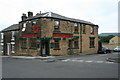
The Spara's
This pub on Gladstone Street I expected to see closed-down and converted to a house.
Instead I find it rebranded with an Irish Theme.
For many years this was a Boddingtons pub called The Victoria Vaults. All the locals however knew it as "The Spara's" after a long-left landlord called Sparrow. Perhaps about eight years ago it was renamed "The Sparrows" with a suitable sign portraying a male passer domesticus but within the last two it has become Flanagan's.
Image: © David Lally
Taken: 29 Aug 2008
0.04 miles
8
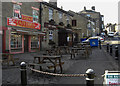
Victoria Street, Glossop
A row of premises set back from the A624, the main road to Hayfield.
Image: © michael ely
Taken: 11 Mar 2010
0.04 miles
9
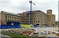
Howardtown Mills, Glossop
This was a once huge complex of 9 acres that dominated the centre of town. This large gritstone block has now been converted to a shopping complex and luxury apartments. The site was originally called Howardtown Mills but seems to have been rebranded following conversion as Howard Town Mills.
Image: © Chris Allen
Taken: 15 Mar 2009
0.04 miles
10
Howardtown Mills, Glossop
This was a once huge complex of 9 acres that dominated the centre of town. This large gritstone block has now been converted to a shopping complex and luxury apartments. The site was originally called Howardtown Mills but seems to have been rebranded following conversion as Howard Town Mills.
Image: © Chris Allen
Taken: 15 Mar 2009
0.04 miles