IMAGES TAKEN NEAR TO
High Street West, GLOSSOP, SK13 8AL
Introduction
This page details the photographs taken nearby to High Street West, SK13 8AL by members of the Geograph project.
The Geograph project started in 2005 with the aim of publishing, organising and preserving representative images for every square kilometre of Great Britain, Ireland and the Isle of Man.

There are currently over 7.5m images from over14,400 individuals and you can help contribute to the project by visiting https://www.geograph.org.uk
Image Map (Loading...)


Getting Data...Please wait
Leaflet Map data © OpenStreetMap
Images are licensed for reuse under creativecommons.org/licenses/by-sa/2.0
Notes
- Clicking on the map will re-center to the selected point.
- The higher the marker number, the further away the image location is from the centre of the postcode.
Image Listing (262 Images Found)
Images are licensed for reuse under creativecommons.org/licenses/by-sa/2.0
Image
Details
Distance
1
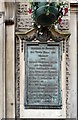
Memorial plaque on Glossop Town Hall
On the side of Glossop Town Hall Image a memorial plaque reads:
BOROUGH OF GLOSSOP
THE TOWN HALL AND
MARKET
AND
CERTAIN MANORIAL RIGHTS
AND FRANCHISES
WERE PURCHASED FROM
LORD HOWARD OF GLOSSOP
AND GENEROUSLY PRESENTED
TO THE CORPORATION OF ~
GLOSSOP BY ~ ~ ~
Mr & Mrs ISAAC JACKSON
HOLLY MOUNT GLOSSOP
IN MEMORY OF THE MEN OF
GLOSSOP AND DISTRICT WHO
SERVED IN THE GREAT WAR
(1914 - 1918)
Image: © Gerald England
Taken: 28 Jun 2009
0.01 miles
2
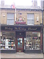
Finlay McKinlay Chemist
High Street West
August 2006
Image: © Caroline Flatt
Taken: 27 Aug 2006
0.01 miles
3
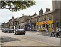
High Street West, Glossop
The main change since December 2008 Image is that the closed Woolworths store has been replaced by Cooltrader.
Image: © Gerald England
Taken: 28 Jun 2009
0.01 miles
4
High Street West from Norfolk Street, Glossop
Image: © Ian S
Taken: 17 Dec 2012
0.01 miles
5
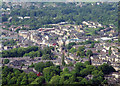
Glossop
In recent years the population of Glossop as been increasing with hundreds of newly built homes springing up on the outskirts of the old town. The railway line provides a relatively easy commute into Manchester.
Image: © Stephen Burton
Taken: 1 Jun 2010
0.02 miles
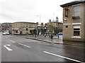
6
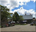
By the High Street in Glossop
The buildings on this stretch of the High Street are set back from the road. Seen from a small green by the war memorial.
Image: © Andrew Hill
Taken: 12 Nov 2011
0.02 miles
7
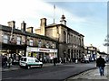
High Street West, Glossop
The Town Hall is topped by a distinctive clock tower. Its arcaded and colonnaded ground floor is now used as a small shopping precinct. Woolworths is about to close its doors for the last time. Cohen's Chemists bears the coat of arms of the Norfolk family.
Image: © Gerald England
Taken: 24 Dec 2008
0.02 miles
8
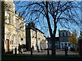
Norfolk Square
In the background covered in scaffolding is the Grade II listed https://historicengland.org.uk/listing/the-list/list-entry/1384269 Town Hall Image
On the left is the Grade II listed https://historicengland.org.uk/listing/the-list/list-entry/1246355 NatWest bank which dates from 1897.
Image: © Gerald England
Taken: 21 May 2019
0.02 miles
9

Glossop Town Hall
From Norfolk Square. The Town Hall is topped by a distinctive clock tower. Its arcaded and colonnaded ground floor is now used as a small shopping precinct.
Image: © Gerald England
Taken: 28 Jun 2009
0.02 miles
10
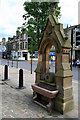
Old Drinking Trough
Norfolk Square, Glossop.
Image: © David Lally
Taken: 13 Aug 2009
0.02 miles