IMAGES TAKEN NEAR TO
Woodhead Road, GLOSSOP, SK13 7QE
Introduction
This page details the photographs taken nearby to Woodhead Road, SK13 7QE by members of the Geograph project.
The Geograph project started in 2005 with the aim of publishing, organising and preserving representative images for every square kilometre of Great Britain, Ireland and the Isle of Man.

There are currently over 7.5m images from over14,400 individuals and you can help contribute to the project by visiting https://www.geograph.org.uk
Image Map (Loading...)


Getting Data...Please wait
Leaflet Map data © OpenStreetMap
Images are licensed for reuse under creativecommons.org/licenses/by-sa/2.0
Notes
- Clicking on the map will re-center to the selected point.
- The higher the marker number, the further away the image location is from the centre of the postcode.
Image Listing (19 Images Found)
Images are licensed for reuse under creativecommons.org/licenses/by-sa/2.0
Image
Details
Distance
1
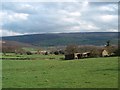
Old farm buildings
Glossop is at the bottom of the hill beyond.
Image: © Bill Boaden
Taken: 18 Apr 2006
0.03 miles
2
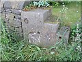
Old Milestone and mounting block by the B6105, Glossop
Carved stone post by the B6105, in parish of Glossop (North East Derbyshire District), Allman's Heath Farm, in gap in stone wall, facing Woodhead Road, on West side of road. Erected by the Wadsley & Langsett - Holmfirth District Turnpike Trust in the 19th century.
Inscription reads:-
GLOSSOP
2 MILE
{arrow to left}
ALFRETON
ROAD
{hand to right}
WINSTER
ROAD
{hand to LEFT}
ASHBURN
ROAD
Milestone Society National ID: DE_GLWH03.
Image: © Milestone Society
Taken: 11 Jun 2017
0.09 miles
3
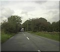
Woodhead Road
View down the B6105 just after Cemetery Road.
Image: © Darren Haddock
Taken: 25 Sep 2006
0.13 miles
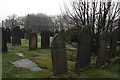
4
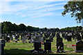
Glossop cemetery.
Along the Peak district boundary walk.
Image: © steven ruffles
Taken: 1 Jul 2018
0.15 miles
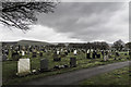
7
Glossop municipal cemetery
Glossop cemetery originally known as Allman's Heath Burial Ground in the early 1900's
Image: © Jane Coop
Taken: 10 Sep 2007
0.19 miles
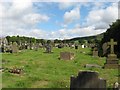
8
Glossop Cemetery
Located on a hilltop above the town.
Image: © Graham Hogg
Taken: 9 Jan 2013
0.20 miles
9
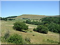
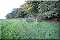
Grazing near Laneside Farm
Off Woodhead Road (B6105).
Image: © JThomas
Taken: 30 Jun 2018
0.22 miles
10
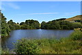
Upper Swineshaw reservoir.
Small reservoir above the larger Swineshaw reservoir.
Image: © steven ruffles
Taken: 1 Jul 2018
0.22 miles