IMAGES TAKEN NEAR TO
Snake Road, GLOSSOP, SK13 7PQ
Introduction
This page details the photographs taken nearby to Snake Road, SK13 7PQ by members of the Geograph project.
The Geograph project started in 2005 with the aim of publishing, organising and preserving representative images for every square kilometre of Great Britain, Ireland and the Isle of Man.

There are currently over 7.5m images from over14,400 individuals and you can help contribute to the project by visiting https://www.geograph.org.uk
Image Map
Images are licensed for reuse under creativecommons.org/licenses/by-sa/2.0
Notes
- Clicking on the map will re-center to the selected point.
- The higher the marker number, the further away the image location is from the centre of the postcode.
Image Listing (22 Images Found)
Images are licensed for reuse under creativecommons.org/licenses/by-sa/2.0
Image
Details
Distance
1
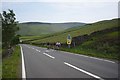
Toiling up the hill
Cyclists making heavy work of a steep rise
Image: © Bob Harvey
Taken: 26 May 2018
0.04 miles
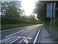
2
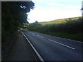
Woodcock Road, Glossop
Looking towards the Snake Pass summit.
Image: © Benjamin Hopkins
Taken: 22 Aug 2010
0.04 miles
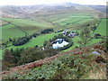
5
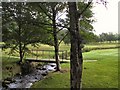
Bridge over Troubled Waters
The footbridge over Hurst Brook, which runs through Glossop golf course.
Image: © Roger May
Taken: 15 Aug 2005
0.12 miles
6
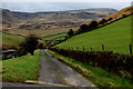
Track leading down into the Valley of Shelf Brook
Passes above Mossy Lea Farm towards Doctor's Gate - an ancient track beside Shelf Brook
Image: © Chris Heaton
Taken: 17 Dec 2015
0.15 miles
7
Snake Pass roadside, looking back at Glossop
Image: © Darrin Antrobus
Taken: 27 Jun 2014
0.15 miles
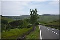
8
Woodcock Road, Glossop
The long descent into Glossop.
Image: © Benjamin Hopkins
Taken: 22 Aug 2010
0.18 miles
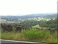
9
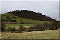
Shire Hill
Hill to the east of Glossop, covered by woodland which partially hides a quarry within its midst.
Image: © Chris Heaton
Taken: 17 Dec 2015
0.18 miles
10
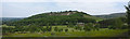
Shire Hill
With a quarry at the top and a golf course at the bottom, this is Shire Hill
Image: © Bob Harvey
Taken: 26 May 2018
0.19 miles