IMAGES TAKEN NEAR TO
North Road, GLOSSOP, SK13 7AS
Introduction
This page details the photographs taken nearby to North Road, SK13 7AS by members of the Geograph project.
The Geograph project started in 2005 with the aim of publishing, organising and preserving representative images for every square kilometre of Great Britain, Ireland and the Isle of Man.

There are currently over 7.5m images from over14,400 individuals and you can help contribute to the project by visiting https://www.geograph.org.uk
Image Map (Loading...)


Getting Data...Please wait
Leaflet Map data © OpenStreetMap
Images are licensed for reuse under creativecommons.org/licenses/by-sa/2.0
Notes
- Clicking on the map will re-center to the selected point.
- The higher the marker number, the further away the image location is from the centre of the postcode.
Image Listing (203 Images Found)
Images are licensed for reuse under creativecommons.org/licenses/by-sa/2.0
Image
Details
Distance
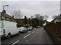
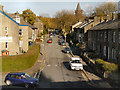
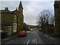
2
Fauvel Road, Glossop
St Lukes C of E Church stands on the left of the photograph with the railway bridge carrying the Glossop to Manchester Piccadilly line in the distance.
Image: © Benjamin Hopkins
Taken: 17 Jan 2010
0.01 miles
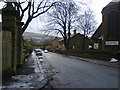
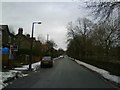
3
Fauvel Road, Glossop
Looking north up Fauvel Road with Glossop Library on the right of the photograph.
Image: © Benjamin Hopkins
Taken: 17 Jan 2010
0.01 miles
4

St Luke's Church, Glossop
Anglican church on Fauvel Road, dating from 1906.
Image: © David Dixon
Taken: 5 Dec 2012
0.03 miles
7
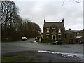
Clare House, Glossop
A five way junction between Lord Street, Fauvel Road, Talbot Street and Spire Hollin.
Image: © Benjamin Hopkins
Taken: 17 Jan 2010
0.07 miles
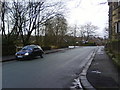
8
Fauvel Road, Glossop
Looking north towards Talbot Road.
Image: © Benjamin Hopkins
Taken: 17 Jan 2010
0.07 miles
9
Lord Street, Glossop
Looking east along Lord Street with the B6105 road at the top of the picture.
Image: © Benjamin Hopkins
Taken: 17 Jan 2010
0.07 miles
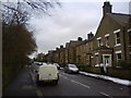
10
Talbot Street, Glossop
On the left of the photograph stands the former Unitarian Chapel constructed in the mid 19th century, it has since be converted into housing.
Image: © Benjamin Hopkins
Taken: 17 Jan 2010
0.07 miles