IMAGES TAKEN NEAR TO
Turnlee Close, GLOSSOP, SK13 6XB
Introduction
This page details the photographs taken nearby to Turnlee Close, SK13 6XB by members of the Geograph project.
The Geograph project started in 2005 with the aim of publishing, organising and preserving representative images for every square kilometre of Great Britain, Ireland and the Isle of Man.

There are currently over 7.5m images from over14,400 individuals and you can help contribute to the project by visiting https://www.geograph.org.uk
Image Map
Images are licensed for reuse under creativecommons.org/licenses/by-sa/2.0
Notes
- Clicking on the map will re-center to the selected point.
- The higher the marker number, the further away the image location is from the centre of the postcode.
Image Listing (32 Images Found)
Images are licensed for reuse under creativecommons.org/licenses/by-sa/2.0
Image
Details
Distance
7
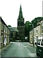
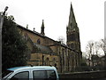
St James' Parish Church
St James' Parish Church on Hollin Cross Lane, Whitfield, Glossop, was founded in 1846.
http://www.glossopheritage.co.uk/cofe.htm#c006 - Glossop Churches and Chapels
Image: © David Dixon
Taken: 8 Oct 2012
0.12 miles
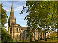
10
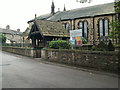
Entrance to St. James' on Hollin Cross Lane
Image: © Raymond Knapman
Taken: 24 Jun 2011
0.12 miles