IMAGES TAKEN NEAR TO
Ravens Close, GLOSSOP, SK13 6QJ
Introduction
This page details the photographs taken nearby to Ravens Close, SK13 6QJ by members of the Geograph project.
The Geograph project started in 2005 with the aim of publishing, organising and preserving representative images for every square kilometre of Great Britain, Ireland and the Isle of Man.

There are currently over 7.5m images from over14,400 individuals and you can help contribute to the project by visiting https://www.geograph.org.uk
Image Map
Images are licensed for reuse under creativecommons.org/licenses/by-sa/2.0
Notes
- Clicking on the map will re-center to the selected point.
- The higher the marker number, the further away the image location is from the centre of the postcode.
Image Listing (6 Images Found)
Images are licensed for reuse under creativecommons.org/licenses/by-sa/2.0
Image
Details
Distance
1
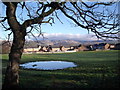
Simmondley, Glossop
Relatively new houses at Simmondley on the outskirts of Glossop. Recent heavy rain has made the field in the foreground somewhat wet.
Image: © Stephen Burton
Taken: 6 Jan 2016
0.01 miles
2
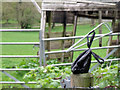
Bagged dog waste
An art form that first surfaced about 20 years ago, the purveyors of this art take enormous pride in the positioning of their excrement bags, barbed wire fences, tree branches and bushes are among the favourite places. A plastic bag is always used to preserve the contents so the public can view it for as long as possible. The artists are incredibly shy the work is always carried out with stealth so just reward is seldom given.https://medium.com/@brookpete/this-dog-poop-bag-photo-series-is-the-nastiest-typology-youll-ever-see-d76c58a32c14
Image: © Stephen Burton
Taken: 7 May 2015
0.11 miles
3
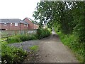
Bridleway approaching Green Lane
The houses are at the end of Kingfisher Way. The track has come from the route through the former Gamesley railway sidings.
Image: © Kevin Waterhouse
Taken: 8 Jul 2024
0.13 miles
4
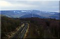
Peak metals
Viewed from the A626 Glossop Road overbridge in Gamesley, the Manchester to Glossop and Hadfield line (ex Manchester, Ashton and Sheffield Railway) curves around North east towards Dinting Junction. Mid ground is Shire Hill to the east of Glossop, and in the background, is Bleaklow plateau.
Image: © Bobby Clegg
Taken: 24 Feb 2013
0.20 miles
5
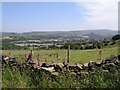
Hargate Hill Lane
View from Hargate Hill Lane at SK012932, looking towards Simmondley and Glossop.
Image: © Alan Fleming
Taken: 28 Jun 2005
0.22 miles
6
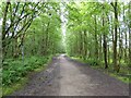
Route following dismantled railway
This track follows the former railway leading to Gamesley sidings beyond the high level bridge that carries Glossop Road. The track runs parallel with the Manchester to Glossop railway line.
Image: © Kevin Waterhouse
Taken: 8 Jul 2024
0.23 miles