IMAGES TAKEN NEAR TO
Primrose Lane, GLOSSOP, SK13 6LW
Introduction
This page details the photographs taken nearby to Primrose Lane, SK13 6LW by members of the Geograph project.
The Geograph project started in 2005 with the aim of publishing, organising and preserving representative images for every square kilometre of Great Britain, Ireland and the Isle of Man.

There are currently over 7.5m images from over14,400 individuals and you can help contribute to the project by visiting https://www.geograph.org.uk
Image Map
Images are licensed for reuse under creativecommons.org/licenses/by-sa/2.0
Notes
- Clicking on the map will re-center to the selected point.
- The higher the marker number, the further away the image location is from the centre of the postcode.
Image Listing (17 Images Found)
Images are licensed for reuse under creativecommons.org/licenses/by-sa/2.0
Image
Details
Distance
1
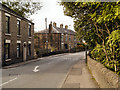
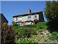
Glossop, Primrose Lane
Stone-built houses on Primrose Lane, near the bridge over Long Clough Brook.
Image: © David Dixon
Taken: 8 Oct 2012
0.04 miles
2
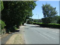
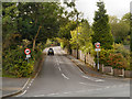
Primrose Lane (A6016) towards Hayfield
Looking south east.
Image: © JThomas
Taken: 30 Jun 2018
0.07 miles
4
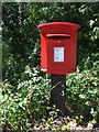
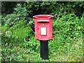
Elizabeth II postbox on Primrose Lane, Glossop
Postbox No. SK13 127.
See Image] for context.
Image: © JThomas
Taken: 30 Jun 2018
0.09 miles
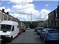
5
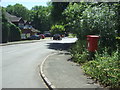
Brookside, Glossop
Showing position of Postbox No. SK13 127.
See Image] for postbox.
Image: © JThomas
Taken: 30 Jun 2018
0.09 miles
9
Simmondley New Road
The road to Simmondley village from Turnlee Road (A6016).
Image: © David Dixon
Taken: 8 Oct 2012
0.13 miles
10
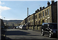
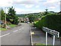
Sunlaws Street, Glossop
Looking towards the hills above Simmondley.
Image: © michael ely
Taken: 11 Mar 2010
0.14 miles