IMAGES TAKEN NEAR TO
Boggard Lane, GLOSSOP, SK13 5HL
Introduction
This page details the photographs taken nearby to Boggard Lane, SK13 5HL by members of the Geograph project.
The Geograph project started in 2005 with the aim of publishing, organising and preserving representative images for every square kilometre of Great Britain, Ireland and the Isle of Man.

There are currently over 7.5m images from over14,400 individuals and you can help contribute to the project by visiting https://www.geograph.org.uk
Image Map
Images are licensed for reuse under creativecommons.org/licenses/by-sa/2.0
Notes
- Clicking on the map will re-center to the selected point.
- The higher the marker number, the further away the image location is from the centre of the postcode.
Image Listing (9 Images Found)
Images are licensed for reuse under creativecommons.org/licenses/by-sa/2.0
Image
Details
Distance
2
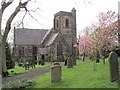
St Johns Church, Charlesworth
St Johns Church in Charlesworth was opened in 1849, and a little later a school and vicarage.
Image: © Alan Fleming
Taken: 30 Apr 2005
0.14 miles
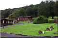
5

Workers' cottages at Coombes Lane Works
Now empty, these were more recently used as offices.
Image: © Bill Boaden
Taken: 19 Aug 2010
0.20 miles
6
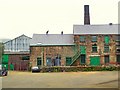
Holehouse Works
At the bottom of a rural cul-de-sac, this Victorian works has its own row of houses for the original workers.
Image: © Roger May
Taken: 15 Aug 2005
0.22 miles
7

Coombes Lane Works
Now almost inevitably derelict, this used to make pigments for the dyeing industry.
Image: © Bill Boaden
Taken: 19 Aug 2010
0.23 miles
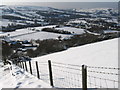
8
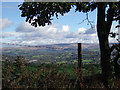
View from Beacon Lane
View from Beacon Lane looking over the River Etherow valley with the hills of the Dark Peak in the distance.
Image: © Stephen Burton
Taken: 20 Oct 2016
0.23 miles
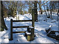
9
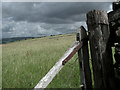
Broken Field Gate
Field gate alongside footpath from Coombes Edge to Charlesworth.
Image: © Stephen Burton
Taken: 21 Aug 2020
0.24 miles