IMAGES TAKEN NEAR TO
Long Lane, GLOSSOP, SK13 5ES
Introduction
This page details the photographs taken nearby to Long Lane, SK13 5ES by members of the Geograph project.
The Geograph project started in 2005 with the aim of publishing, organising and preserving representative images for every square kilometre of Great Britain, Ireland and the Isle of Man.

There are currently over 7.5m images from over14,400 individuals and you can help contribute to the project by visiting https://www.geograph.org.uk
Image Map
Images are licensed for reuse under creativecommons.org/licenses/by-sa/2.0
Notes
- Clicking on the map will re-center to the selected point.
- The higher the marker number, the further away the image location is from the centre of the postcode.
Image Listing (27 Images Found)
Images are licensed for reuse under creativecommons.org/licenses/by-sa/2.0
Image
Details
Distance
1
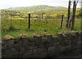
Bank Wood Gate
The view from Bank Wood Gate on Long Lane.
Image: © Gerald England
Taken: 12 May 2010
0.02 miles
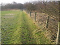
3

Footpath to Mote Hall Farm
Public footpath but private road to Mote Hall Farm.
Image: © Gerald England
Taken: 12 Jul 2012
0.11 miles
5
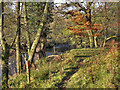
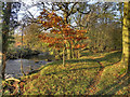
Riverside Path
The path near the bank of the River Etherow, near Image
Image: © David Dixon
Taken: 19 Nov 2011
0.18 miles
6
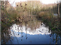
Gamesley Woodlands (wildlife pond)
Gamesley Woodlands runs alongside the Manchester to Glossop rail line, it was originally railway sidings which formed part of the Mottram and Dinting Marshalling Yard. When the sidings closed pioneer tree species appeared, recently a bridleway has been laid and this pond constructed for the benefit of the public.
Image: © Stephen Burton
Taken: 3 Feb 2016
0.18 miles
7
River Etherow, Riverside Path
The path along the bank of the River Etherow, near Image
Image: © David Dixon
Taken: 19 Nov 2011
0.18 miles
8
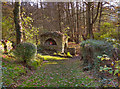
The Church of The Immaculate Conception, Broadbottom
The stone-built grotto over a spring at the south eastern corner of the churchyard.
Image: © David Dixon
Taken: 19 Nov 2011
0.18 miles
9
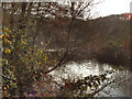
River Etherow
Looking downstream from the bank to the south of Image
Image: © David Dixon
Taken: 19 Nov 2011
0.19 miles
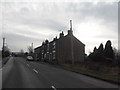
10
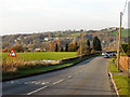
Long Lane
Long Lane, between Charlesworth and Broadbottom.
Image: © David Dixon
Taken: 19 Nov 2011
0.19 miles