IMAGES TAKEN NEAR TO
Bankwood, GLOSSOP, SK13 5ER
Introduction
This page details the photographs taken nearby to Bankwood, SK13 5ER by members of the Geograph project.
The Geograph project started in 2005 with the aim of publishing, organising and preserving representative images for every square kilometre of Great Britain, Ireland and the Isle of Man.

There are currently over 7.5m images from over14,400 individuals and you can help contribute to the project by visiting https://www.geograph.org.uk
Image Map
Images are licensed for reuse under creativecommons.org/licenses/by-sa/2.0
Notes
- Clicking on the map will re-center to the selected point.
- The higher the marker number, the further away the image location is from the centre of the postcode.
Image Listing (19 Images Found)
Images are licensed for reuse under creativecommons.org/licenses/by-sa/2.0
Image
Details
Distance
1
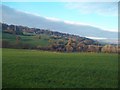
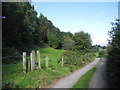
Grassland near the River Etherow
Looking across the river valley from the Trans Pennine Trail.
Image: © Jonathan Clitheroe
Taken: 23 Nov 2013
0.06 miles
2
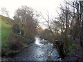
The River Etherow near Broadbottom
Looking upstream on a cold Saturday in late November. The river marks the Derbyshire / Greater Manchester county boundary here and the Trans Pennine Trail also follows the riverbank for a short distance before climbing out of the valley towards Gamesley.
Image: © Jonathan Clitheroe
Taken: 23 Nov 2013
0.07 miles
3
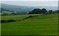
Derbyshire countryside east of Hague Road
Image: © Neil Theasby
Taken: 8 Jun 2021
0.17 miles
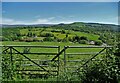
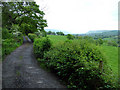
4

Hague Road
Hague Road is a private road but is a public footpath. On the horizon you can see the upper end of the Longdendale Valley cutting into the Pennine Hills.
Image: © Stephen Burton
Taken: 11 Oct 2014
0.17 miles
6
Pingot Lane footpath and Hague Road
Footpath leading to Pingot Lane/Mottram Hill, from Hague Road.
Image: © John Topping
Taken: 29 Sep 2013
0.17 miles
7
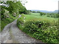
The Pennine Bridleway interim route near Broadbottom
Image: © Dave Kelly
Taken: 27 May 2019
0.18 miles
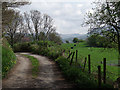
8
Hague Road
This private road/footpath links Broadbottom with Woolley Bridge or Dinting. It is an agreeable lane lined with Hawthorn; in the distance, you can see the hills of the Dark Peak.
Image: © Stephen Burton
Taken: 14 May 2007
0.19 miles
10
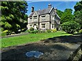
The Hague on Hague Road
Grand house near Broadbottom
Image: © Neil Theasby
Taken: 8 Jun 2021
0.21 miles