IMAGES TAKEN NEAR TO
Roundhill Close, GLOSSOP, SK13 2BH
Introduction
This page details the photographs taken nearby to Roundhill Close, SK13 2BH by members of the Geograph project.
The Geograph project started in 2005 with the aim of publishing, organising and preserving representative images for every square kilometre of Great Britain, Ireland and the Isle of Man.

There are currently over 7.5m images from over14,400 individuals and you can help contribute to the project by visiting https://www.geograph.org.uk
Image Map (Loading...)


Getting Data...Please wait
Leaflet Map data © OpenStreetMap
Images are licensed for reuse under creativecommons.org/licenses/by-sa/2.0
Notes
- Clicking on the map will re-center to the selected point.
- The higher the marker number, the further away the image location is from the centre of the postcode.
Image Listing (13 Images Found)
Images are licensed for reuse under creativecommons.org/licenses/by-sa/2.0
Image
Details
Distance
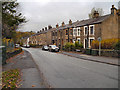
1
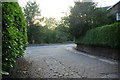
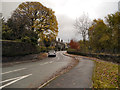
The Shaw
Part of an older road, with new houses built near it. Here it joins the point where Shaw Avenue becomes Dinting Road.
Image: © Bill Boaden
Taken: 13 Oct 2010
0.05 miles
3
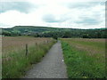
Path leading to Dinting Vale from Hadfield
Image: © Raymond Knapman
Taken: 24 Jun 2011
0.10 miles
4
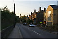
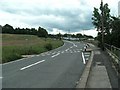
Shaw Lane
Linking Hadfield and the A57 with Dinting.
Image: © Bill Boaden
Taken: 13 Oct 2010
0.12 miles
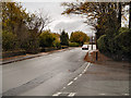
6
Footpath crossing Dinting Road
Car park for Dinting Station in distance
Image: © Raymond Knapman
Taken: 24 Jun 2011
0.16 miles
8
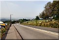
Dinting Road
Leading past the entrance to the car park for Dinting Station.
Image: © Gerald England
Taken: 15 Sep 2016
0.21 miles
10

Dinting Station car park
A large car park for commuters near Dinting Station.
Image: © Gerald England
Taken: 15 Sep 2016
0.22 miles