IMAGES TAKEN NEAR TO
Chapel Lane, GLOSSOP, SK13 1PG
Introduction
This page details the photographs taken nearby to Chapel Lane, SK13 1PG by members of the Geograph project.
The Geograph project started in 2005 with the aim of publishing, organising and preserving representative images for every square kilometre of Great Britain, Ireland and the Isle of Man.

There are currently over 7.5m images from over14,400 individuals and you can help contribute to the project by visiting https://www.geograph.org.uk
Image Map (Loading...)


Getting Data...Please wait
Leaflet Map data © OpenStreetMap
Images are licensed for reuse under creativecommons.org/licenses/by-sa/2.0
Notes
- Clicking on the map will re-center to the selected point.
- The higher the marker number, the further away the image location is from the centre of the postcode.
Image Listing (23 Images Found)
Images are licensed for reuse under creativecommons.org/licenses/by-sa/2.0
Image
Details
Distance
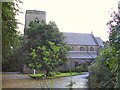
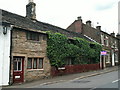
2
Church Hall
The hall for the RC Church of St Charles Borromeo at Hadfield which appears disused
Image: © Kevin Waterhouse
Taken: 6 Aug 2024
0.09 miles
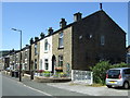
3
Hadfield Road, Hadfield
Looking north west.
Image: © JThomas
Taken: 30 Jun 2018
0.15 miles
4
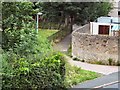
Short Cut
The pathway linking Mersey Bank Estate to Hadfield Road.
Image: © Roger May
Taken: 12 Aug 2005
0.17 miles
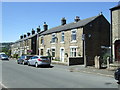
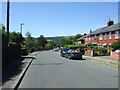
6
Terraced housing on Hadfield Road, Hadfield
Image: © JThomas
Taken: 30 Jun 2018
0.21 miles
8
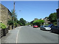
Woolley Bridge Road, Hadfield
Looking north east.
Image: © JThomas
Taken: 30 Jun 2018
0.22 miles
9
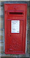
Edward VII postbox on Queen Street, Hadfield
Postbox No. SK13 166.
Image: © JThomas
Taken: 30 Jun 2018
0.22 miles
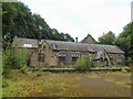
10
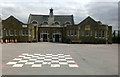
St Andrew's Junior School
On Hadfield Road, Hadfield.
Originally the building was a fire Station.
Image: © David Lally
Taken: 13 Aug 2009
0.23 miles