IMAGES TAKEN NEAR TO
Platt Street, GLOSSOP, SK13 1EY
Introduction
This page details the photographs taken nearby to Platt Street, SK13 1EY by members of the Geograph project.
The Geograph project started in 2005 with the aim of publishing, organising and preserving representative images for every square kilometre of Great Britain, Ireland and the Isle of Man.

There are currently over 7.5m images from over14,400 individuals and you can help contribute to the project by visiting https://www.geograph.org.uk
Image Map
Images are licensed for reuse under creativecommons.org/licenses/by-sa/2.0
Notes
- Clicking on the map will re-center to the selected point.
- The higher the marker number, the further away the image location is from the centre of the postcode.
Image Listing (52 Images Found)
Images are licensed for reuse under creativecommons.org/licenses/by-sa/2.0
Image
Details
Distance
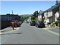
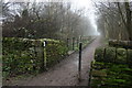
2
Old and new houses in Padfield
On the south side of the Longdendale Trail, a former railway line.
Image: © Christine Johnstone
Taken: 12 Feb 2016
0.09 miles
3
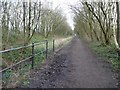
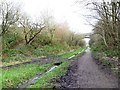
The start of the Longdendale Trail
The former electrified Woodhead railway line from Sheffield to Manchester. Looking north-eastwards near the car park off Pratt Street, Hadfield.
Image: © Christine Johnstone
Taken: 12 Feb 2016
0.10 miles
4
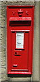
Victorian postbox on Platt Street, Padfield
Postbox No. SK14 167.
Image: © JThomas
Taken: 30 Jun 2018
0.10 miles
5
The start of the Longdendale Trail
A 6.6 mile trail which follows the alignment of the old Woodhead railway line to the east of Hadfield. It also forms part of the Trans Pennine Trail.
Image: © Graham Hogg
Taken: 9 Jan 2013
0.11 miles
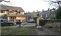
6
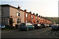
Brick houses in Post Street Padfield
An information board outside the pub says that are made of brick rather than stone because they were built before the railways arrived.
Image: © Chris
Taken: 11 Sep 2014
0.11 miles
8
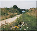
Longdendale Trail with bridge
The bridge is the Hadfield to Padfield road. The trail is part of the Trans-Pennine Route (National Cycle Route 62) and follows the route of the old Great Central Railway.
Image: © Stephen Craven
Taken: 14 Aug 1993
0.13 miles
10
The Longdendale Trail, heading north east
About to pass under the Padfield Main Road bridge, which [presumably] the informal path leads up to.
Image: © Christine Johnstone
Taken: 12 Feb 2016
0.14 miles