IMAGES TAKEN NEAR TO
Rhodes Street, GLOSSOP, SK13 1EQ
Introduction
This page details the photographs taken nearby to Rhodes Street, SK13 1EQ by members of the Geograph project.
The Geograph project started in 2005 with the aim of publishing, organising and preserving representative images for every square kilometre of Great Britain, Ireland and the Isle of Man.

There are currently over 7.5m images from over14,400 individuals and you can help contribute to the project by visiting https://www.geograph.org.uk
Image Map (Loading...)


Getting Data...Please wait
Leaflet Map data © OpenStreetMap
Images are licensed for reuse under creativecommons.org/licenses/by-sa/2.0
Notes
- Clicking on the map will re-center to the selected point.
- The higher the marker number, the further away the image location is from the centre of the postcode.
Image Listing (30 Images Found)
Images are licensed for reuse under creativecommons.org/licenses/by-sa/2.0
Image
Details
Distance
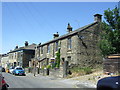
1
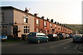
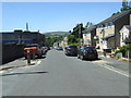
Brick houses in Post Street Padfield
An information board outside the pub says that are made of brick rather than stone because they were built before the railways arrived.
Image: © Chris
Taken: 11 Sep 2014
0.04 miles
5
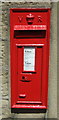
Victorian postbox on Platt Street, Padfield
Postbox No. SK14 167.
Image: © JThomas
Taken: 30 Jun 2018
0.07 miles
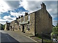
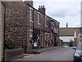
7
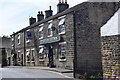
Peels arms public house.
Pub in Padfield.
Image: © steven ruffles
Taken: 1 Jul 2018
0.08 miles
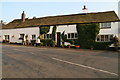
10
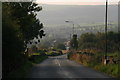
Main Road out of Padfield towards Tintwistle
Image: © Chris
Taken: 11 Sep 2014
0.10 miles