IMAGES TAKEN NEAR TO
SK12 6DU
Introduction
This page details the photographs taken nearby to SK12 6DU by members of the Geograph project.
The Geograph project started in 2005 with the aim of publishing, organising and preserving representative images for every square kilometre of Great Britain, Ireland and the Isle of Man.

There are currently over 7.5m images from over14,400 individuals and you can help contribute to the project by visiting https://www.geograph.org.uk
Image Map
Images are licensed for reuse under creativecommons.org/licenses/by-sa/2.0
Notes
- Clicking on the map will re-center to the selected point.
- The higher the marker number, the further away the image location is from the centre of the postcode.
Image Listing (24 Images Found)
Images are licensed for reuse under creativecommons.org/licenses/by-sa/2.0
Image
Details
Distance
1
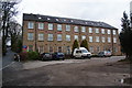
Bridgeholm Mill
Now converted into flats but there is a new industrial estate just next to it.
Image: © Bill Boaden
Taken: 10 Mar 2012
0.03 miles
2
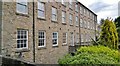
Old Mill at Bridgeholme Green
Now converted into apartments.
Image: © Chris Morgan
Taken: 17 Jun 2013
0.03 miles
3
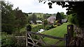
Millpond at Bridgeholm Green
The mill has been converted to residential use and the garden surrounding the pond has a one hole golf course!
Image: © Graham Hogg
Taken: 17 Jun 2013
0.03 miles
4
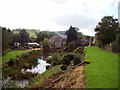
Mill Pond at Bridgeholm Green
Mill pond and public footpath running alongside to the right of picture. The converted mill in the background is situated on Charley Lane.
Image: © Jonathan Clitheroe
Taken: 22 Sep 2011
0.05 miles
5
Just west of Chapel Milton Viaducts looking westward along derelict track which leads to Buxworth Basin
Image: © marplerambler
Taken: 5 Jun 2011
0.10 miles
6
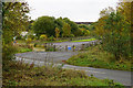
The far end of the Ferodo test track
Now part of Federal Mogul, the site manufactures rubber and tests tyres here.
Image: © Bill Boaden
Taken: 17 Oct 2015
0.10 miles
7
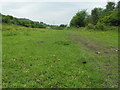
Track of the old Peak Forest Tramway
This part now used for testing brake products made by Federal Mogul (Ferodo). The Tramway goes back 200 years. The modern dual carriageway A6 is in the trees on the right.
Image: © Chris Morgan
Taken: 17 Jun 2013
0.11 miles
8
Former tramway at Bridgeholm Green
Part of the Peak Forest Tramway, a horse and gravity powered railway built in the late 18th century to carry limestone from the quarries around Doveholes Image to the Peak Forest Canal at Bugsworth Basin Image
Image: © Graham Hogg
Taken: 17 Jun 2013
0.13 miles
9
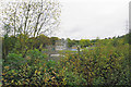
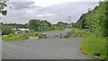
Chapel-en-le-Frith Wastewater Treatment Works
As can be seen, it is quite well shielded by foliage.
Image: © Bill Boaden
Taken: 17 Oct 2015
0.17 miles
10
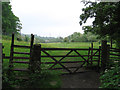
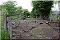
Chinley - footpath from Chapel Milton to Bridgeholm Green
For an alternative view, please see Image
Image: © Dave Bevis
Taken: 2 Jun 2012
0.20 miles