IMAGES TAKEN NEAR TO
SK12 3DF
Introduction
This page details the photographs taken nearby to SK12 3DF by members of the Geograph project.
The Geograph project started in 2005 with the aim of publishing, organising and preserving representative images for every square kilometre of Great Britain, Ireland and the Isle of Man.

There are currently over 7.5m images from over14,400 individuals and you can help contribute to the project by visiting https://www.geograph.org.uk
Image Map
Images are licensed for reuse under creativecommons.org/licenses/by-sa/2.0
Notes
- Clicking on the map will re-center to the selected point.
- The higher the marker number, the further away the image location is from the centre of the postcode.
Image Listing (8 Images Found)
Images are licensed for reuse under creativecommons.org/licenses/by-sa/2.0
Image
Details
Distance
1
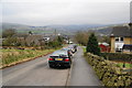
The top end of New Mills
Looking down Eaves Knoll Road on the edge of the town.
Image: © Bill Boaden
Taken: 5 Mar 2011
0.06 miles
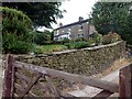
2
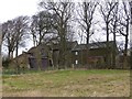
Eaves Knoll Farmhouse
Grade II listed farmhouse on the outskirts of New Mills https://historicengland.org.uk/listing/the-list/list-entry/1039939.
Image: © Dave Dunford
Taken: 1 Jan 2015
0.13 miles
3
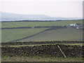
Grazing on Eaves Knoll
Farmland west of High Lee, New Mills. The Cage in Lyme Park is on the horizon, left.
Image: © Peter Barr
Taken: 28 Mar 2011
0.16 miles
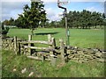
4
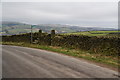
A footpath off Eaves Knoll Road
The view behind looks down the Goyt Valley, towards Disley and the Lantern in Lyme Park.
Image: © Bill Boaden
Taken: 5 Mar 2011
0.17 miles
5
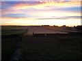
Sunest over Eaves Knoll
A colourful end to a warm and sunny September day near New Mills.
Image: © Jonathan Clitheroe
Taken: 8 Sep 2012
0.19 miles
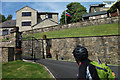
7
Lark Hill
A large detached house on Brook Bottom Road, to the west of New Mills.
Image: © Graham Hogg
Taken: 10 Sep 2012
0.22 miles
8
Houses on Brook Bottom Road, New Mills
One of them is flying the Russian flag.
Image: © michael ely
Taken: 21 May 2014
0.25 miles