IMAGES TAKEN NEAR TO
Buxton Road, STOCKPORT, SK12 2RQ
Introduction
This page details the photographs taken nearby to Buxton Road, SK12 2RQ by members of the Geograph project.
The Geograph project started in 2005 with the aim of publishing, organising and preserving representative images for every square kilometre of Great Britain, Ireland and the Isle of Man.

There are currently over 7.5m images from over14,400 individuals and you can help contribute to the project by visiting https://www.geograph.org.uk
Image Map
Images are licensed for reuse under creativecommons.org/licenses/by-sa/2.0
Notes
- Clicking on the map will re-center to the selected point.
- The higher the marker number, the further away the image location is from the centre of the postcode.
Image Listing (20 Images Found)
Images are licensed for reuse under creativecommons.org/licenses/by-sa/2.0
Image
Details
Distance
1
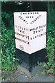
Old Milepost by the A6, east of Disley
Cast iron post by the A6, in parish of Disley (Macclesfield District), roadside, in tarmac path in front of bank, on South side of road. Cast iron CCC1898, erected by the County Council in the 19th century.
Inscription reads:-
: DISLEY / 1 MILE / STOCKPORT 7¾ / MANCHESTER / 14 : : CHESHIRE / 1898 / COUNTY COUNCIL : : WHALEY BRIDGE / 3 MILES / BUXTON 10 :
Maker:-
: W H SMITH & CO / MAKERS / WHITCHURCH :
Milestone Society National ID: CH_LM174
Image: © J Higgins
Taken: 1 Jun 2003
0.12 miles
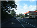
2
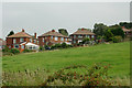
Pasture and housing west of Newtown, Cheshire
Seen from the Peak Forest Canal. The housing on the right is in Overdale Road, south-west of New Mills.
Image: © Roger D Kidd
Taken: 5 Sep 2014
0.13 miles
3
Pasture and housing west of Newtown, Cheshire
Seen from the Peak Forest Canal. The housing on the right is in Overdale Road, south-west of New Mills.
Image: © Roger D Kidd
Taken: 5 Sep 2014
0.14 miles
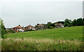
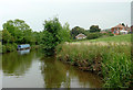
4

Peak Forest Canal west of Newtown, Cheshire
The housing on the right is in Overdale Road, south-west of New Mills.
Image: © Roger D Kidd
Taken: 5 Sep 2014
0.15 miles
5
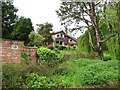
Canalside house, Overdale Road
On the south bank of the Peak Forest Canal.
Image: © Christine Johnstone
Taken: 11 May 2014
0.15 miles
7
Peak Forest Canal west of Newtown, Cheshire
The housing on the right is in Overdale Road, south-west of New Mills.
Image: © Roger D Kidd
Taken: 5 Sep 2014
0.16 miles
8
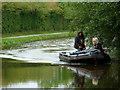
Please avoid causing a wash....
... to minimise erosion of the canal banks.
Even the speed limit on the canals of 4 mph is often too fast to prevent damaging waves. It is not only a small number of ill informed hire-boat drivers who are responsible.
Peak Forest Canal, north-east of Green's Hall Bridge.
Image: © Roger D Kidd
Taken: 5 Sep 2014
0.17 miles
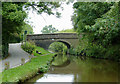
9
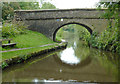
Green's Hall Bridge west of Newtown, Cheshire
Bridge No 27 across the Peak Forest Canal carries Lower Greenshall Lane.
Image: © Roger D Kidd
Taken: 5 Sep 2014
0.17 miles
10
Green's Hall Bridge west of Newtown, Cheshire
Bridge No 27 across the Peak Forest Canal carries Lower Greenshall Lane.
Substantial wooden bollards discourage drivers from deviating into the canal here from the narrow road serving Cloughside Farm.
Image: © Roger D Kidd
Taken: 5 Sep 2014
0.17 miles