IMAGES TAKEN NEAR TO
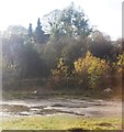
Redhouse Lane, STOCKPORT, SK12 2HL
Introduction
This page details the photographs taken nearby to Redhouse Lane, SK12 2HL by members of the Geograph project.
The Geograph project started in 2005 with the aim of publishing, organising and preserving representative images for every square kilometre of Great Britain, Ireland and the Isle of Man.

There are currently over 7.5m images from over14,400 individuals and you can help contribute to the project by visiting https://www.geograph.org.uk
Image Map
Images are licensed for reuse under creativecommons.org/licenses/by-sa/2.0
Notes
- Clicking on the map will re-center to the selected point.
- The higher the marker number, the further away the image location is from the centre of the postcode.
Image Listing (41 Images Found)
Images are licensed for reuse under creativecommons.org/licenses/by-sa/2.0
Image
Details
Distance
1
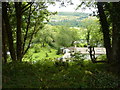
House and garden at Waterside, on the banks of the River Goyt
Between Disley and Hague Bar, just north of the Peak Forest Canal.
Image: © Peter Barr
Taken: 1 Aug 2011
0.04 miles
2
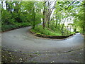
Hairpin bend in the Disley to Hague Bar road
Image: © John H Darch
Taken: 24 May 2013
0.04 miles
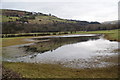
5
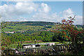
Farmland and woodland north-east of Danebank in Cheshire
Looking north-east across the Goyt Valley from the Upper Peak Forest Canal, and towards Burymewick Wood near Cloughside Farm.
Railway: The Manchester to Buxton Line crosses the scene at the far side of the field.
Image: © Roger Kidd
Taken: 7 Sep 2014
0.08 miles
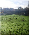
6
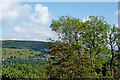
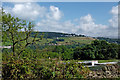
View across the Goyt Valley near Danebank in Cheshire
Near Cloughside Farm, looking north across Higgins Clough and the Goyt Valley from the Upper Peak Forest Canal. Across the valley are houses on High Lea Road.
Image: © Roger Kidd
Taken: 7 Sep 2014
0.09 miles
7
Farmland north-east of Danebank in Cheshire
Looking north-east from the Upper Peak Forest Canal towards Burymewick Wood near Cloughside Farm.
Image: © Roger Kidd
Taken: 7 Sep 2014
0.10 miles
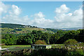
9
View across the Goyt Valley near Danebank in Cheshire
Near Cloughside Farm, looking north-east across Burymewick Wood and the Goyt Valley from the Upper Peak Forest Canal. Near the skyline are houses on High Lea Road.
Image: © Roger Kidd
Taken: 7 Sep 2014
0.12 miles