IMAGES TAKEN NEAR TO
Middlewood Road, STOCKPORT, SK12 1TS
Introduction
This page details the photographs taken nearby to Middlewood Road, SK12 1TS by members of the Geograph project.
The Geograph project started in 2005 with the aim of publishing, organising and preserving representative images for every square kilometre of Great Britain, Ireland and the Isle of Man.

There are currently over 7.5m images from over14,400 individuals and you can help contribute to the project by visiting https://www.geograph.org.uk
Image Map
Images are licensed for reuse under creativecommons.org/licenses/by-sa/2.0
Notes
- Clicking on the map will re-center to the selected point.
- The higher the marker number, the further away the image location is from the centre of the postcode.
Image Listing (4 Images Found)
Images are licensed for reuse under creativecommons.org/licenses/by-sa/2.0
Image
Details
Distance
1
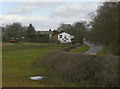
Middlewood Road
Passing the site of Horsepastures Pit, in the field to the left.
Image: © Alan Murray-Rust
Taken: 25 Mar 2010
0.16 miles
2
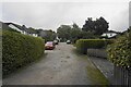
Prince Road
A private residential road in Higher Poynton viewed on a wet day.
Image: © Bill Boaden
Taken: 29 Sep 2022
0.20 miles
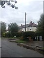
4

Prince's Incline from the bridge over the old railway
For the opposite view click http://www.geograph.org.uk/photo/3065566 .
Image: © Peter Turner
Taken: 30 Jun 2012
0.24 miles