IMAGES TAKEN NEAR TO
The Coppice, STOCKPORT, SK12 1SR
Introduction
This page details the photographs taken nearby to The Coppice, SK12 1SR by members of the Geograph project.
The Geograph project started in 2005 with the aim of publishing, organising and preserving representative images for every square kilometre of Great Britain, Ireland and the Isle of Man.

There are currently over 7.5m images from over14,400 individuals and you can help contribute to the project by visiting https://www.geograph.org.uk
Image Map
Images are licensed for reuse under creativecommons.org/licenses/by-sa/2.0
Notes
- Clicking on the map will re-center to the selected point.
- The higher the marker number, the further away the image location is from the centre of the postcode.
Image Listing (6 Images Found)
Images are licensed for reuse under creativecommons.org/licenses/by-sa/2.0
Image
Details
Distance
1
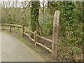
Fence at Poynton Coppice Local Nature Reserve
Image: © Graham Hogg
Taken: 12 Apr 2019
0.06 miles
2
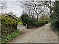
Lane approaching Keeper's Cottage
Keeper's Cottage is the building in the distance with Blue-Green windows
Image: © Philip Cornwall
Taken: 28 Sep 2020
0.06 miles
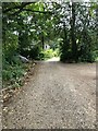
3
Lane running along Northern boundary of Poynton Coppice
Image: © Philip Cornwall
Taken: 28 Sep 2020
0.08 miles
4
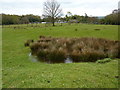
On a footpath from Wardsend to Hockley
Farmland east of Poynton.
Image: © Peter Barr
Taken: 24 Apr 2012
0.11 miles
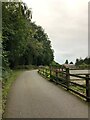
5
Unadopted road through Poynton Coppice
Image: © Chris Morgan
Taken: 12 Apr 2019
0.17 miles
6
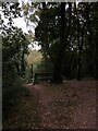
Glade with bench in Poynton Coppice
Image: © Philip Cornwall
Taken: 28 Sep 2020
0.22 miles