IMAGES TAKEN NEAR TO
Chester Road, STOCKPORT, SK12 1DS
Introduction
This page details the photographs taken nearby to Chester Road, SK12 1DS by members of the Geograph project.
The Geograph project started in 2005 with the aim of publishing, organising and preserving representative images for every square kilometre of Great Britain, Ireland and the Isle of Man.

There are currently over 7.5m images from over14,400 individuals and you can help contribute to the project by visiting https://www.geograph.org.uk
Image Map
Images are licensed for reuse under creativecommons.org/licenses/by-sa/2.0
Notes
- Clicking on the map will re-center to the selected point.
- The higher the marker number, the further away the image location is from the centre of the postcode.
Image Listing (11 Images Found)
Images are licensed for reuse under creativecommons.org/licenses/by-sa/2.0
Image
Details
Distance
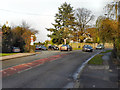
1
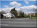
Pointin' to Poynton
Junction of Woodford Road and the A5149 Chester Road on the outskirts of Poynton.
Image: © Roger May
Taken: 13 Nov 2005
0.07 miles
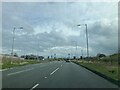
2
A5149 Chester Road, Poynton
Heading for Woodford.
Image: © John Topping
Taken: 3 Apr 2013
0.10 miles
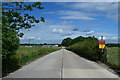
3

Footpath; impassable
Overgrown path at junction of Woodford Road and A5149.
Image: © Peter Barr
Taken: 30 Jul 2012
0.12 miles
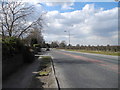
4
Chester Road (A5149)
The A5149, Chester Road between Bramhall and Poynton, at its junction with Woodford Road (from Hazel Grove).
Image: © David Dixon
Taken: 12 Nov 2011
0.14 miles
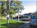
5
Woodford Road, Poynton
Viewed at the junction with Chester Road (A5149).
Image: © John Topping
Taken: 3 Apr 2013
0.14 miles
6
Concrete surfaced road, leading to a depot
The footpath on which I would have been walking was inaccessible at SJ903837; Image] the path crosses this access road, which leads to what appears to be an oil storage and distribution depot.
Image: © Peter Barr
Taken: 30 Jul 2012
0.15 miles
7
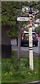
Old Direction Sign - Signpost by Chester Road, Poynton with Worth Parish
Pawn finial - 1 arm; Cheshire CC post by the A5149 Chester Road, junction with Woodford Road, in parish of Poynton with Worth (Macclesfield District).
Appears to be lost before Streetview 2009.
Surveyed
Milestone Society National ID: CH_SJ9083
Image: © Milestone Society
Taken: Unknown
0.15 miles
8

A555 Sign just before opening
A555 Sign just before opening - also includes Poynton Bypass Direction
Image: © Steve Nicklin
Taken: 8 Sep 2018
0.17 miles
9
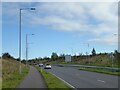
Cyclepath by the A555
Heading towards High Lane on the new road from Manchester Airport.
Image: © Kevin Waterhouse
Taken: 14 Oct 2024
0.20 miles