IMAGES TAKEN NEAR TO
Bridgefield Street, STOCKPORT, SK1 1SA
Introduction
This page details the photographs taken nearby to Bridgefield Street, SK1 1SA by members of the Geograph project.
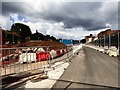
The Geograph project started in 2005 with the aim of publishing, organising and preserving representative images for every square kilometre of Great Britain, Ireland and the Isle of Man.

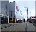
There are currently over 7.5m images from over14,400 individuals and you can help contribute to the project by visiting https://www.geograph.org.uk
Image Map
Images are licensed for reuse under creativecommons.org/licenses/by-sa/2.0
Notes
- Clicking on the map will re-center to the selected point.
- The higher the marker number, the further away the image location is from the centre of the postcode.
Image Listing (1576 Images Found)
Images are licensed for reuse under creativecommons.org/licenses/by-sa/2.0
Image
Details
Distance
1
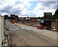
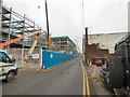
Redrock development site
One lane of Bridgefield Street is now contained within the site and the former ramp Image from the car park to the roof of Debenham's has gone.
Image: © Gerald England
Taken: 25 Jun 2016
0.01 miles
2
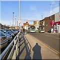
Bridgefield Street
For buses into Stockport from the north-east sector Bridgefield Street is the main route in and out.
Image: © Gerald England
Taken: 7 Mar 2015
0.02 miles
3
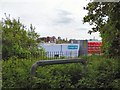
View from Heaton Norris Park
The Town Hall can be seen in the background but the foreground is now dominated by the Redrock Development.
Image: © Gerald England
Taken: 17 May 2018
0.02 miles
4
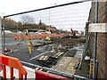
Digging up Bridgefield Street
As part of the Redrock Development Bridgefield Street is being dug up. The workmen were having a tea break when this photograph was taken.
Image: © Gerald England
Taken: 25 Jan 2016
0.02 miles
5
Redrock now completed
The Redrock development alongside Bridgefield Street is now up an running. Beyond the restaurant Zizzi is a new cinema called "The Light".
Image: © Gerald England
Taken: 15 Dec 2017
0.02 miles
6
Redrock development site
On the right is one lane of Bridgefield Street which has been divided off and partially incorporated into the site. On the left is the former car park off Great Egerton Street.
Image: © Gerald England
Taken: 25 Jun 2016
0.02 miles
7
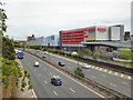
Redrock across the M60
Looking across the M60 motorway towards the Redrock Development. On the right is the NCP multi-storey car park accessed via a spiral ramp or a bridge from the car park above Debenhams. On the left is a cinema called "the light".
Image: © Gerald England
Taken: 17 May 2018
0.02 miles
8
Bridgefield Street
Work on the Redrock development continues.
Image: © Gerald England
Taken: 6 Dec 2016
0.02 miles
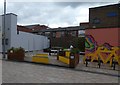
9
Seating area off Bridgefield Street
As part of the Redrock Development the site of a demolished building has been turned into a seating area with a bright mural on one side.
Image: © Gerald England
Taken: 8 Jul 2019
0.03 miles
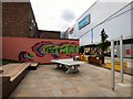
10
Bridgefield Street Pocket Park
A pocket park has been installed on Bridgfield Street featuring seating, greenery, cycle parking, an art wall, a concrete table tennis table and chimes for children to play with. It is the first of the Bee Network of parklets to be created through the Mayor of Manchester's Cycling and Walking Challenge Fund and Transport for Greater Manchester. Table tennis bats and a ball can be borrowed from Mango Bean across the way on the Redrock development.
Image: © Gerald England
Taken: 7 Sep 2019
0.03 miles