IMAGES TAKEN NEAR TO
Dark Lane, MACCLESFIELD, SK11 9QZ
Introduction
This page details the photographs taken nearby to Dark Lane, SK11 9QZ by members of the Geograph project.
The Geograph project started in 2005 with the aim of publishing, organising and preserving representative images for every square kilometre of Great Britain, Ireland and the Isle of Man.

There are currently over 7.5m images from over14,400 individuals and you can help contribute to the project by visiting https://www.geograph.org.uk
Image Map
Images are licensed for reuse under creativecommons.org/licenses/by-sa/2.0
Notes
- Clicking on the map will re-center to the selected point.
- The higher the marker number, the further away the image location is from the centre of the postcode.
Image Listing (4 Images Found)
Images are licensed for reuse under creativecommons.org/licenses/by-sa/2.0
Image
Details
Distance
1
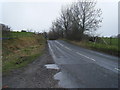
Gawsworth Road/Dark Lane junction
Left to Gawsworth and the A536 to Congleton, right to Pexhill and the B5392 to Holmes Chapel.
Image: © Peter Turner
Taken: 28 Apr 2011
0.04 miles
3
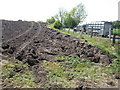
Recently ploughed
Beside Gawsworth Road a recently ploughed field awaiting its harrowing and sowing. What will be the crop? Too late for oilseed rape but maybe corn/maize. Both are appearing in fields locally that seem normally for grazing.
Image: © Peter Turner
Taken: 28 Apr 2011
0.22 miles