IMAGES TAKEN NEAR TO
Henbury, MACCLESFIELD, SK11 9PL
Introduction
This page details the photographs taken nearby to SK11 9PL by members of the Geograph project.
The Geograph project started in 2005 with the aim of publishing, organising and preserving representative images for every square kilometre of Great Britain, Ireland and the Isle of Man.

There are currently over 7.5m images from over14,400 individuals and you can help contribute to the project by visiting https://www.geograph.org.uk
Image Map
Images are licensed for reuse under creativecommons.org/licenses/by-sa/2.0
Notes
- Clicking on the map will re-center to the selected point.
- The higher the marker number, the further away the image location is from the centre of the postcode.
Image Listing (6 Images Found)
Images are licensed for reuse under creativecommons.org/licenses/by-sa/2.0
Image
Details
Distance
1
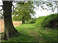
Along the track from Lingard's
Seemingly an overgrown farmtrack or access road with mature trees in a line away from the remaining hedge.
Image: © Peter Turner
Taken: 28 Apr 2011
0.07 miles
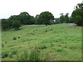
3
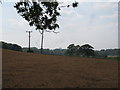
There's Jodrell Bank
The perennial cry (or just thought) when the familiar disc of the radio telescope structure appears on the horizon or glimpsed through the trees. The grass in the field appears to have been subjected to a heavy dose of weedkiller. Possibly as a precurser to resowing with some monocultural high-yielding crop of grass for the horses stabled at Lingards Farm.
Image: © Peter Turner
Taken: 28 Apr 2011
0.15 miles
4
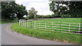
Iron fencing on Fanshawe Lane near Henbury Smithy
Well worth preserving, and there's plenty of it in Cheshire.
Image
Image: © Geoff Royle
Taken: 26 Aug 2012
0.18 miles
6
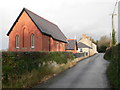
Tremeirchion Methodist Church.
Foundation stone was laid in 1888.
Image: © Eirian Evans
Taken: 5 Dec 2007
0.24 miles