IMAGES TAKEN NEAR TO
Dark Lane, MACCLESFIELD, SK11 9PE
Introduction
This page details the photographs taken nearby to Dark Lane, SK11 9PE by members of the Geograph project.
The Geograph project started in 2005 with the aim of publishing, organising and preserving representative images for every square kilometre of Great Britain, Ireland and the Isle of Man.

There are currently over 7.5m images from over14,400 individuals and you can help contribute to the project by visiting https://www.geograph.org.uk
Image Map
Images are licensed for reuse under creativecommons.org/licenses/by-sa/2.0
Notes
- Clicking on the map will re-center to the selected point.
- The higher the marker number, the further away the image location is from the centre of the postcode.
Image Listing (10 Images Found)
Images are licensed for reuse under creativecommons.org/licenses/by-sa/2.0
Image
Details
Distance
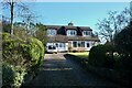
2
Around Henbury (21)
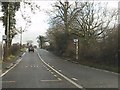
On Andertons Lane
Image: © Anthony O'Neil
Taken: 27 Feb 2022
0.18 miles
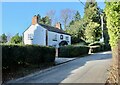
4
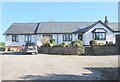
Around Henbury (20)
Glencree, Andertons Lane
Image: © Anthony O'Neil
Taken: 27 Feb 2022
0.21 miles
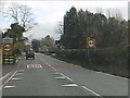
6

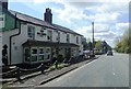
The Blacksmith's Arms
A pub on the A537 Chester Road at Henbury to the west of Macclesfield.
Image: © Jonathan Billinger
Taken: 21 Aug 2007
0.22 miles
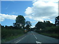
9
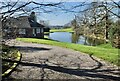
Outskirts of Henbury
View over the fields from the junction of Church Lane, Dark Lane and Andertons Lane.
Image: © michael ely
Taken: 12 Apr 2006
0.23 miles
10
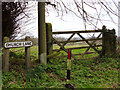
Around Henbury (18)
West View, Andertons Lane
Image: © Anthony O'Neil
Taken: 27 Feb 2022
0.25 miles