IMAGES TAKEN NEAR TO
Siddington, MACCLESFIELD, SK11 9ND
Introduction
This page details the photographs taken nearby to SK11 9ND by members of the Geograph project.
The Geograph project started in 2005 with the aim of publishing, organising and preserving representative images for every square kilometre of Great Britain, Ireland and the Isle of Man.

There are currently over 7.5m images from over14,400 individuals and you can help contribute to the project by visiting https://www.geograph.org.uk
Image Map
Images are licensed for reuse under creativecommons.org/licenses/by-sa/2.0
Notes
- Clicking on the map will re-center to the selected point.
- The higher the marker number, the further away the image location is from the centre of the postcode.
Image Listing (5 Images Found)
Images are licensed for reuse under creativecommons.org/licenses/by-sa/2.0
Image
Details
Distance
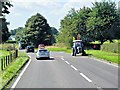
3
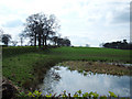
Pond near Mere Moss
Looking west along the line of Blackden Lane (left of shot) from the side of the A34, Congleton Road. The pond is shown on the OS 1/25,000 map.
Image: © michael ely
Taken: 19 Apr 2006
0.17 miles
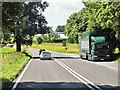
4
Blackden Lane Siddington
The main road at the bottom is the A34 with Wilmslow to the left and Congleton the right. The entry on the right foreground is the entrance to Toll Bar Farm.
Image: © Peter Turner
Taken: 22 Feb 2012
0.19 miles
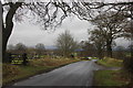
5
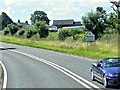
Congleton Road, Marton
The boundary sign at Marton Bridge
Image: © David Dixon
Taken: 17 Jul 2014
0.25 miles