IMAGES TAKEN NEAR TO
Colshaw Lane, MACCLESFIELD, SK11 9LZ
Introduction
This page details the photographs taken nearby to Colshaw Lane, SK11 9LZ by members of the Geograph project.
The Geograph project started in 2005 with the aim of publishing, organising and preserving representative images for every square kilometre of Great Britain, Ireland and the Isle of Man.

There are currently over 7.5m images from over14,400 individuals and you can help contribute to the project by visiting https://www.geograph.org.uk
Image Map
Images are licensed for reuse under creativecommons.org/licenses/by-sa/2.0
Notes
- Clicking on the map will re-center to the selected point.
- The higher the marker number, the further away the image location is from the centre of the postcode.
Image Listing (8 Images Found)
Images are licensed for reuse under creativecommons.org/licenses/by-sa/2.0
Image
Details
Distance
1
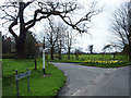
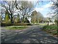
Siddington Heath
A picturesque crossroads of Cheshire lanes.
Image: © michael ely
Taken: 19 Apr 2006
0.12 miles
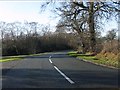
2
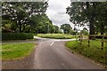
Hodgehill
Road junction at Hodgehill.
Image: © Peter McDermott
Taken: 11 Jul 2015
0.14 miles
3
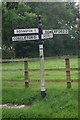
Old Direction Sign - Signpost by Blackden Lane, Hodge Hill, Siddington Parish
Pawn finial - 4 arms; Cheshire CCC octagonal by the UC road, in parish of Siddington (Macclesfield District), Blackden Lane junction with Boundary Lane and Colshaw Lane.
Surveyed
Milestone Society National ID: CH_SJ8369
Image: © Milestone Society
Taken: Unknown
0.15 miles
4
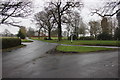
Blackden Lane/Colshaw Lane/ Chapel Lane junction Siddington
Image: © Peter Turner
Taken: 22 Feb 2012
0.15 miles
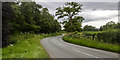
6
Salters Lane at Siddington village boundary
Image: © Colin Pyle
Taken: 22 Mar 2014
0.20 miles
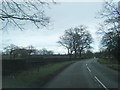
7
Salters Lane
View looking across along Salters Lane.
Image: © Peter McDermott
Taken: 11 Jul 2015
0.22 miles
8
Colshaw Lane junction, Siddington Heath
Image: © Peter Whatley
Taken: 19 Jan 2012
0.24 miles