IMAGES TAKEN NEAR TO
Capesthorne, Siddington, MACCLESFIELD, SK11 9JZ
Introduction
This page details the photographs taken nearby to SK11 9JZ by members of the Geograph project.
The Geograph project started in 2005 with the aim of publishing, organising and preserving representative images for every square kilometre of Great Britain, Ireland and the Isle of Man.

There are currently over 7.5m images from over14,400 individuals and you can help contribute to the project by visiting https://www.geograph.org.uk
Image Map
Images are licensed for reuse under creativecommons.org/licenses/by-sa/2.0
Notes
- Clicking on the map will re-center to the selected point.
- The higher the marker number, the further away the image location is from the centre of the postcode.
Image Listing (8 Images Found)
Images are licensed for reuse under creativecommons.org/licenses/by-sa/2.0
Image
Details
Distance
1
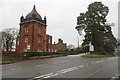
Capesthorne Park North Lodge
Just off the A34 the entrance to the Home Farm as well as the lodge.
Image: © Peter Turner
Taken: 22 Feb 2012
0.03 miles
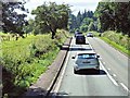
3
Bagbrook Bridge, Congleton Road, Siddington
A busy A34 looking south with Bagbrook Farm just visible on the right.
Image: © Peter Turner
Taken: 22 Feb 2012
0.13 miles
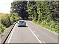
4
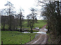
Bag Brook, Monks Heath
A farm track fords Bag Brook adjacent to Bagbrook Bridge that carries the A34.
The track runs parallel to the A34, Congleton Road for a while.
Image: © michael ely
Taken: 12 Apr 2006
0.14 miles
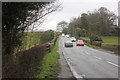
5
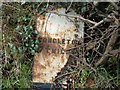
Toppled Milestone, Bagbrook Bridge
This cast iron milestone is marked on the OS maps about 300m south of the Monks Heath cross roads. Unfortunately it is lying on its back (this is an aerial photo) in the hedgerow alongside the A34, Congleton Road. A combination of creeping ivy and rust will soon render it illegible.
Image: © michael ely
Taken: 12 Apr 2006
0.14 miles
6
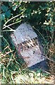
Old Milepost by the A34 at Bagbrook Bridge
Cast iron post by the A34, in parish of Siddington (Macclesfield District), Bagbrook Bridge, in hedge, on West side of road. Cast iron CCC1896, erected by the County Council in the 19th century.
Inscription reads:-
: ALDERLEY EDGE / 3 MILES / WILMSLOW 5 / HANDFORTH 6 / CHEADLE 10 / MANCHESTER 17 : : CHESHIRE / 1896 / COUNTY COUNCIL : : CONGLETON / 7¾ MILES :
Maker:-
: W H SMITH & CO / MAKER / WHITCHURCH :
Milestone Society National ID: CH_AECO03
Image: © J Higgins
Taken: 1 Aug 2003
0.16 miles
7
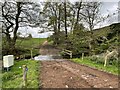
Bag Brook Ford
This ford on the Bag Brook is found at Monksheath Hall Farm at Monk’s Heath.
Image: © John Walton
Taken: 1 May 2022
0.19 miles