IMAGES TAKEN NEAR TO
Pexall Road, MACCLESFIELD, SK11 9HZ
Introduction
This page details the photographs taken nearby to Pexall Road, SK11 9HZ by members of the Geograph project.
The Geograph project started in 2005 with the aim of publishing, organising and preserving representative images for every square kilometre of Great Britain, Ireland and the Isle of Man.

There are currently over 7.5m images from over14,400 individuals and you can help contribute to the project by visiting https://www.geograph.org.uk
Image Map
Images are licensed for reuse under creativecommons.org/licenses/by-sa/2.0
Notes
- Clicking on the map will re-center to the selected point.
- The higher the marker number, the further away the image location is from the centre of the postcode.
Image Listing (16 Images Found)
Images are licensed for reuse under creativecommons.org/licenses/by-sa/2.0
Image
Details
Distance
1
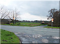
Rodeheath crossroads
The junction of the A536 (Macclesfield Road) with Pexhall Road and Cocksmoss Lane.
Image: © michael ely
Taken: 19 Apr 2006
0.04 miles
2
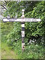
Old Direction Sign - Signpost by the A536 Macclesfield Road
Located on the southwest side of the crossroads of the A536 Macclesfield Road, Pexall Road and Marton Lane/Cocksmoss Lane at Rode Heath in North Rode parish. 4 arms and pawn finial. See also https://www.geograph.org.uk/photo/6072405.
Milestone Society National ID: CH_SJ8767
Image: © C Marcus
Taken: Unknown
0.09 miles
3
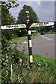
Direction Sign ? Signpost on the A536 Macclesfield Road
Located on the southwest side of the crossroads of the A536 Macclesfield Road, Pexall Road and Marton Lane/Cocksmoss Lane at Rode Heath in North Rode parish. 4 arms and pawn finial. See also https://www.geograph.org.uk/photo/6043036.
Milestone Society National ID: CH_SJ8767
Image: © S Charles
Taken: 2 Sep 2015
0.09 miles
4
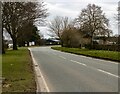
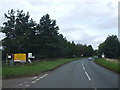
A536
Macclesfield Road at Rodeheath.
Image: © Peter McDermott
Taken: 6 Mar 2021
0.11 miles
6
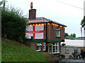
Chain and Gate
Is this an inn, or is it an antique shop? Or both?
Image: © Neil Lewin
Taken: 13 Aug 2006
0.12 miles
7
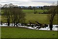
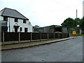
Rode Heath Farm
Waterlogged land on Rode Heath Farm seen from Pexall Road.
Image: © Peter McDermott
Taken: 6 Mar 2021
0.13 miles
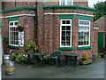
9
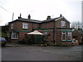
The Chain & Gate pub
Locally known as the Cheyney Gate.
Image: © Richard Law
Taken: 21 Jan 2009
0.15 miles
10
New Pastures Farm
and 'Platts New Pastures Farm Shop'
Image: © Neil Lewin
Taken: 13 Aug 2006
0.16 miles