IMAGES TAKEN NEAR TO
Forge Close, MACCLESFIELD, SK11 9EW
Introduction
This page details the photographs taken nearby to Forge Close, SK11 9EW by members of the Geograph project.
The Geograph project started in 2005 with the aim of publishing, organising and preserving representative images for every square kilometre of Great Britain, Ireland and the Isle of Man.

There are currently over 7.5m images from over14,400 individuals and you can help contribute to the project by visiting https://www.geograph.org.uk
Image Map
Images are licensed for reuse under creativecommons.org/licenses/by-sa/2.0
Notes
- Clicking on the map will re-center to the selected point.
- The higher the marker number, the further away the image location is from the centre of the postcode.
Image Listing (7 Images Found)
Images are licensed for reuse under creativecommons.org/licenses/by-sa/2.0
Image
Details
Distance
2
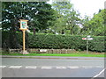
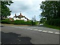
Gawsworth Village Sign
Seen from the junction of Woodhouse Lane (in the foreground) with Church Lane. The village sign, on the left, was recently installed, on 10 July. Details are given on the village website: http://www.gawsworthpc.org.uk/gawsworth-village-sign/
Image: © David Weston
Taken: 7 Aug 2015
0.09 miles
3
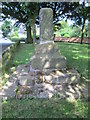
Ancient Cross, Gawsworth
A market cross, at the corner of a triangle of grass in the village. Church Lane is on the left.
Image: © David Weston
Taken: 7 Aug 2015
0.09 miles
4
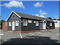
Gawsworth Village Hall
On Church Lane. Part of the Scout Hut is seen on the right.
Image: © David Weston
Taken: 7 Aug 2015
0.12 miles
5
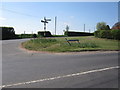
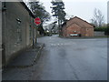
Gawsworth Road/Dark Lane junction
Left to Gawsworth and the A536 to Congleton, right to Pexhill and the B5392 to Holmes Chapel.
Image: © Peter Turner
Taken: 28 Apr 2011
0.22 miles
6
Wardle Crescent, Gawsworth
Despite the name, the road is straight, although there is a slight curve to the row of former council houses. The road forms part of Sustrans route 55. Properly, this part of the village is Warren, Gawsworth proper consisting of the small number of buildings round the Hall and church.
Image: © Alan Murray-Rust
Taken: 9 Aug 2016
0.24 miles