IMAGES TAKEN NEAR TO
Salters Lane, MACCLESFIELD, SK11 9EE
Introduction
This page details the photographs taken nearby to Salters Lane, SK11 9EE by members of the Geograph project.
The Geograph project started in 2005 with the aim of publishing, organising and preserving representative images for every square kilometre of Great Britain, Ireland and the Isle of Man.

There are currently over 7.5m images from over14,400 individuals and you can help contribute to the project by visiting https://www.geograph.org.uk
Image Map
Images are licensed for reuse under creativecommons.org/licenses/by-sa/2.0
Notes
- Clicking on the map will re-center to the selected point.
- The higher the marker number, the further away the image location is from the centre of the postcode.
Image Listing (11 Images Found)
Images are licensed for reuse under creativecommons.org/licenses/by-sa/2.0
Image
Details
Distance
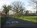
1
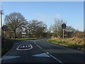
Eastern lane junction, Lower Withington
Image: © Peter Whatley
Taken: 19 Jan 2012
0.10 miles
3
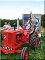
Lower Withington Rose Day Float - Olympic Hopefuls
Float entered in the Lower Withington 60th Rose Day 1949-2009 - Olympic Hopefuls
Image: © Paul Kennington
Taken: 4 Jul 2009
0.13 miles
4

Lower Withington Rose Day - tractors in waiting
Tractors assembled ready for the Rose Day procession
Image: © Paul Kennington
Taken: 4 Jul 2009
0.13 miles
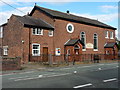
6
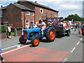
Lower Withington Rose Day procession
Lower Withington Rose Day procession - Methodist Church in background
Image: © Paul Kennington
Taken: 4 Jul 2009
0.15 miles
8
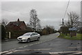
B5392 at The Green Lower Withington
Branching off the B5392 is the start of Trap Street that eventually leads to Congleton. The Green glimpsed behind the road signs is depressed below road level which may indicate a drained pond or mere.
Image: © Peter Turner
Taken: 22 Feb 2012
0.19 miles
9
Trap Street, Lower Withington
Looking down to the end wall of the Red Lion public house owned by Robinsons of Stockport. Which was named first, the pub or the brook that runs by it?
Image: © Peter Turner
Taken: 22 Feb 2012
0.20 miles
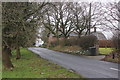
10
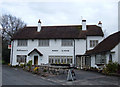
The Red Lion, Lower Withington
Situated on Trap Street just north of Redlion Bridge that takes the road over Redlion Brook. The OS 1940s map shows a pub called the Cob Inn here.
Image: © michael ely
Taken: 19 Apr 2006
0.21 miles