IMAGES TAKEN NEAR TO
Pepper Street, MACCLESFIELD, SK11 9BE
Introduction
This page details the photographs taken nearby to Pepper Street, SK11 9BE by members of the Geograph project.
The Geograph project started in 2005 with the aim of publishing, organising and preserving representative images for every square kilometre of Great Britain, Ireland and the Isle of Man.

There are currently over 7.5m images from over14,400 individuals and you can help contribute to the project by visiting https://www.geograph.org.uk
Image Map
Images are licensed for reuse under creativecommons.org/licenses/by-sa/2.0
Notes
- Clicking on the map will re-center to the selected point.
- The higher the marker number, the further away the image location is from the centre of the postcode.
Image Listing (8 Images Found)
Images are licensed for reuse under creativecommons.org/licenses/by-sa/2.0
Image
Details
Distance

4
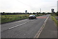
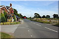
The A537 (Chelford Road)
The A537 (Chelford Road) heading west at Chelford towards Knutsford. Taken from outside the Egerton Arms.
Image: © Jeff Buck
Taken: 7 Aug 2014
0.24 miles

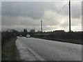
7
The A537 (Chelford Road)
The A537 (Chelford Road) heading east at Chelford towards the village of Chelford. Taken from outside the Egerton Arms.
Image: © Jeff Buck
Taken: 7 Aug 2014
0.25 miles
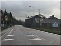
8
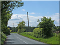
Pepper Street, Chelford
Looking SW down the lane from its junction with the A537, Knutsford Road.
Image: © michael ely
Taken: 30 May 2006
0.25 miles