IMAGES TAKEN NEAR TO
The Uplands, Bishopton Drive, MACCLESFIELD, SK11 8WG
Introduction
This page details the photographs taken nearby to The Uplands, Bishopton Drive, SK11 8WG by members of the Geograph project.
The Geograph project started in 2005 with the aim of publishing, organising and preserving representative images for every square kilometre of Great Britain, Ireland and the Isle of Man.

There are currently over 7.5m images from over14,400 individuals and you can help contribute to the project by visiting https://www.geograph.org.uk
Image Map
Images are licensed for reuse under creativecommons.org/licenses/by-sa/2.0
Notes
- Clicking on the map will re-center to the selected point.
- The higher the marker number, the further away the image location is from the centre of the postcode.
Image Listing (7 Images Found)
Images are licensed for reuse under creativecommons.org/licenses/by-sa/2.0
Image
Details
Distance
2
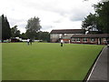
Macclesfield Bowling Club
Crown-green bowling club secretly situated at the back of the Macclesfield Cricket Club ground off Victoria Road.
Image: © Peter Turner
Taken: 9 Aug 2011
0.07 miles
3
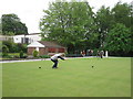
Parkside Bowling Club
Formerly part of the Parkside Mental Hospital which has been disbanded as a hospital some years ago and the grounds and buildings sold off to developers. The quite striking Victorian wards and other similar buildings have been made into apartments and the grounds filled with 'Executive Homes'.
Image: © Peter Turner
Taken: 13 May 2011
0.08 miles
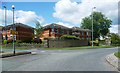
6

Pool at Macclesfield General Hospital
complete with resident ducks.
Image: © Neil Lewin
Taken: 13 Aug 2006
0.17 miles
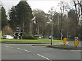
7
Traffic lights at the hospital entrance
Image: © Peter Whatley
Taken: 19 Jan 2012
0.22 miles