IMAGES TAKEN NEAR TO
Chester Road, MACCLESFIELD, SK11 8RA
Introduction
This page details the photographs taken nearby to Chester Road, SK11 8RA by members of the Geograph project.
The Geograph project started in 2005 with the aim of publishing, organising and preserving representative images for every square kilometre of Great Britain, Ireland and the Isle of Man.

There are currently over 7.5m images from over14,400 individuals and you can help contribute to the project by visiting https://www.geograph.org.uk
Image Map
Images are licensed for reuse under creativecommons.org/licenses/by-sa/2.0
Notes
- Clicking on the map will re-center to the selected point.
- The higher the marker number, the further away the image location is from the centre of the postcode.
Image Listing (13 Images Found)
Images are licensed for reuse under creativecommons.org/licenses/by-sa/2.0
Image
Details
Distance
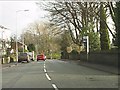
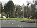
3
Broken Cross
This is the street name of this section of the A537, the main road from Macclesfield to Chester.
Image: © Alan Murray-Rust
Taken: 9 Jun 2009
0.13 miles
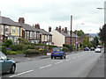
6
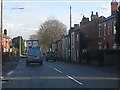
Terraced houses alongside the A537, Broken Cross
Image: © Peter Whatley
Taken: 19 Jan 2012
0.17 miles
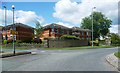
7
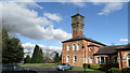
Clock tower at former Parkside Hospital, Macclesfield
Image: © Colin Park
Taken: 6 Mar 2016
0.19 miles
8
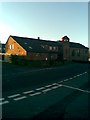
St John's church
St John's church, Weston estate.
Image: © darren kimpton
Taken: 29 Dec 2009
0.19 miles
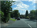
9
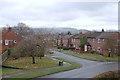
Wilwick Lane Weston estate
Wilwick Lane looking towards Buxton hills.
Image: © darren kimpton
Taken: 14 Nov 2008
0.19 miles
10
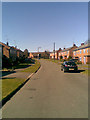
Wilwick Lane, Macclesfield
Wilwick Lane, Weston Estate.
Image: © darren kimpton
Taken: 8 Mar 2011
0.19 miles