IMAGES TAKEN NEAR TO
Arlington Drive, MACCLESFIELD, SK11 8QL
Introduction
This page details the photographs taken nearby to Arlington Drive, SK11 8QL by members of the Geograph project.
The Geograph project started in 2005 with the aim of publishing, organising and preserving representative images for every square kilometre of Great Britain, Ireland and the Isle of Man.

There are currently over 7.5m images from over14,400 individuals and you can help contribute to the project by visiting https://www.geograph.org.uk
Image Map
Images are licensed for reuse under creativecommons.org/licenses/by-sa/2.0
Notes
- Clicking on the map will re-center to the selected point.
- The higher the marker number, the further away the image location is from the centre of the postcode.
Image Listing (7 Images Found)
Images are licensed for reuse under creativecommons.org/licenses/by-sa/2.0
Image
Details
Distance
1
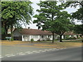
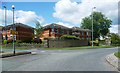
Bungalows on Ivy Road, Macclesfield
Near the junction with Bransdale Way, shown on the left.
Image: © David Weston
Taken: 10 Jul 2018
0.15 miles
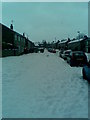
3
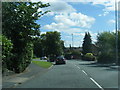
Wilwick Lane, Macclesfield
Wilwick Lane, Weston Estate.
Image: © darren kimpton
Taken: 8 Mar 2011
0.17 miles
7
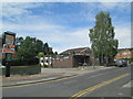
The Ivy Leaf, Macclesfield
A pub at the junction of Ivy Road with Dawson Road.
Image: © David Weston
Taken: 10 Jul 2018
0.24 miles