IMAGES TAKEN NEAR TO
Moss Lane, MACCLESFIELD, SK11 7XH
Introduction
This page details the photographs taken nearby to Moss Lane, SK11 7XH by members of the Geograph project.
The Geograph project started in 2005 with the aim of publishing, organising and preserving representative images for every square kilometre of Great Britain, Ireland and the Isle of Man.

There are currently over 7.5m images from over14,400 individuals and you can help contribute to the project by visiting https://www.geograph.org.uk
Image Map
Images are licensed for reuse under creativecommons.org/licenses/by-sa/2.0
Notes
- Clicking on the map will re-center to the selected point.
- The higher the marker number, the further away the image location is from the centre of the postcode.
Image Listing (7 Images Found)
Images are licensed for reuse under creativecommons.org/licenses/by-sa/2.0
Image
Details
Distance
1
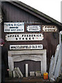
Street nameplates, reclamation yard, Macclesfield
On the extensive premises of Cheshire Demolitions, Moss Lane.
Image: © Robin Stott
Taken: 4 Dec 2009
0.12 miles
2

Reclamation yard, Moss Lane, Macclesfield
The extensive premises of Cheshire Demolitions. Besides the architectural antiques such as these fountains much space is given over to reclaimed materials: bricks, stone, sleepers, slates, chimney pots...
Image: © Robin Stott
Taken: 4 Dec 2009
0.12 miles

4

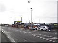
Macclesfield Football Club
The Leasing.com Stadium.
Image: © JThomas
Taken: 5 Jul 2024
0.24 miles
5
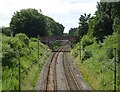
Railway towards Congleton
The Stafford to Manchester Line.
Image: © JThomas
Taken: 5 Jul 2024
0.24 miles
6
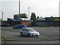
Moss Rose - Home of the Silkmen
Across London Road (A523) the football ground of Macclesfield Town AFC.
Image: © Peter Turner
Taken: 14 Dec 2011
0.25 miles
7
Northeast corner, Macclesfield Town football ground
The view from Moss Lane near the London Road junction.
Image: © Robin Stott
Taken: 28 Apr 2011
0.25 miles