IMAGES TAKEN NEAR TO
Hollins Terrace, MACCLESFIELD, SK11 7EB
Introduction
This page details the photographs taken nearby to Hollins Terrace, SK11 7EB by members of the Geograph project.
The Geograph project started in 2005 with the aim of publishing, organising and preserving representative images for every square kilometre of Great Britain, Ireland and the Isle of Man.

There are currently over 7.5m images from over14,400 individuals and you can help contribute to the project by visiting https://www.geograph.org.uk
Image Map
Images are licensed for reuse under creativecommons.org/licenses/by-sa/2.0
Notes
- Clicking on the map will re-center to the selected point.
- The higher the marker number, the further away the image location is from the centre of the postcode.
Image Listing (56 Images Found)
Images are licensed for reuse under creativecommons.org/licenses/by-sa/2.0
Image
Details
Distance
1
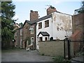
Houses, Hollins Terrace, Macclesfield
On the 1873 OS map this spot off Pott Lane (now Hollins Road) is called Court No 1.
Image: © Robin Stott
Taken: 28 Apr 2011
0.01 miles
2
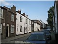
Hollins Road, Macclesfield
Formerly Pott Lane, the continuation of Windmill Street up the hill.
Image: © Robin Stott
Taken: 28 Apr 2011
0.03 miles
4
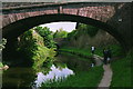
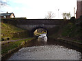
Macclesfield - Verdon Bridge
See Image for a view in the opposite directions.
Image: © Dave Bevis
Taken: 1 May 1999
0.08 miles
5
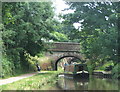
Two bridges on the Macclesfield Canal at Macclesfield 2005
Leadbeaters Bridge - no.40 - and Verdons Bridge - no.41. The canal here passes through a fairly narrow cutting even though it is built on the side of a hill.
The best place to moor for Macclesfield town centre is at Buxton Road Bridge - no.37.
Image: © Maurice Pullin
Taken: 17 Jul 2005
0.09 miles
6
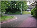
Goodwood Close, Macclesfield
Recent residential development off Hollins Road, conceivably on the site of 19th-century detached gardens.
Image: © Robin Stott
Taken: 28 Apr 2011
0.10 miles
7
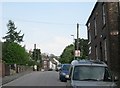
Nearing canal bridge, Windmill Street, Macclesfield
The plate on the house wall, right, reads "Court No 3". The OS map of 1871-3 shows it as an access to the rear of terraced houses in Black Road. A notable feature of the map of this area is the extensive mosaic of detached gardens on this steep west-facing hillside, now mostly built on.
Image: © Robin Stott
Taken: 28 Apr 2011
0.10 miles
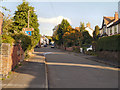
8
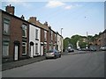
Blakelow Road, Macclesfield
Looking uphill from the junction with Hollins Road, right, (formerly Pott Lane) and the top of Windmill Street.
Image: © Robin Stott
Taken: 28 Apr 2011
0.10 miles
9
Macclesfield Canal: Leadbeaters Bridge No 40
Image: © Dr Neil Clifton
Taken: 31 Mar 2015
0.11 miles
10
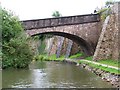
Bridge 41, Macclesfield Canal
A particularly fine bridge which spans the canal between high retaining walls and incorporates a significant gradient from one side to the other.
Image: © David Martin
Taken: 4 Aug 2010
0.11 miles