IMAGES TAKEN NEAR TO
Wilmslow Walk, MACCLESFIELD, SK11 7DY
Introduction
This page details the photographs taken nearby to Wilmslow Walk, SK11 7DY by members of the Geograph project.
The Geograph project started in 2005 with the aim of publishing, organising and preserving representative images for every square kilometre of Great Britain, Ireland and the Isle of Man.

There are currently over 7.5m images from over14,400 individuals and you can help contribute to the project by visiting https://www.geograph.org.uk
Image Map
Images are licensed for reuse under creativecommons.org/licenses/by-sa/2.0
Notes
- Clicking on the map will re-center to the selected point.
- The higher the marker number, the further away the image location is from the centre of the postcode.
Image Listing (140 Images Found)
Images are licensed for reuse under creativecommons.org/licenses/by-sa/2.0
Image
Details
Distance
1
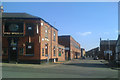
Looking along Goodall Street, Macclesfield
The Wharf public house, on the corner with Brook Street, is closed. Slightly odd appearance is because the corner is greater than a right angle.
Image: © Robin Stott
Taken: 27 Apr 2011
0.08 miles
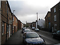
2
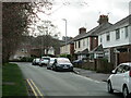
Swettenham Street, Macclesfield
A residential street east of the town centre.
Image: © David Weston
Taken: 24 Mar 2021
0.10 miles
3
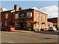
The Wharf
The Wharf public house at the corner of Brook Street and Goodall Street in Macclesfield.
Image: © David Dixon
Taken: 3 Oct 2012
0.11 miles
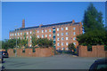
7
The Hovis Mill seen from Fountain Street, Macclesfield
The mill has been converted to flats in a stunning location overlooking the canal and the town Image
Image: © Robin Stott
Taken: 4 Dec 2009
0.12 miles
8
Hovis Mill flats, Macclesfield
The gated entrance from Union Road.
Image: © Robin Stott
Taken: 27 Apr 2011
0.12 miles
9
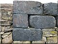
Blocks of slag from historic smelting by Macclesfield Copper Company
Blocks of black slag, with occasional bubbles within the wall behind the pub.
These are traces of the Macclesfield Copper Company which smelted copper and bronze in the area in the C18th.
Other traces are in nearby street names: Copper Street, Windmill Street and Calamine Street. Calamine is an ore of zinc for making brass; a windmill was used to crush it. Charles Roe ran the company - Roe Street is in his name.
Image: © Simon Wellings
Taken: 8 Apr 2021
0.12 miles
10
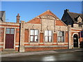
St Peter's War Memorial Hall, Windmill Street, Macclesfield
Image: © Colin Park
Taken: 18 Jan 2009
0.12 miles